IMAGES TAKEN NEAR TO
Ferry Toll Road, DUNFERMLINE, KY11 2UZ
Introduction
This page details the photographs taken nearby to Ferry Toll Road, KY11 2UZ by members of the Geograph project.
The Geograph project started in 2005 with the aim of publishing, organising and preserving representative images for every square kilometre of Great Britain, Ireland and the Isle of Man.

There are currently over 7.5m images from over14,400 individuals and you can help contribute to the project by visiting https://www.geograph.org.uk
Image Map
Images are licensed for reuse under creativecommons.org/licenses/by-sa/2.0
Notes
- Clicking on the map will re-center to the selected point.
- The higher the marker number, the further away the image location is from the centre of the postcode.
Image Listing (26 Images Found)
Images are licensed for reuse under creativecommons.org/licenses/by-sa/2.0
Image
Details
Distance
1
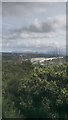
View from New Whinny Hill
If you go by the maps the only hill that could be Whinny Hill is here - it is a noticeable bump on the Southern slope of Castlandhill. It is shown to the right of here on paper maps, on a slope of this hill. When you zoom in online Whinny Hill is actually in the middle of the motorway! So it seems likely that there may have been a more pronounced bump, not quite as high as from where this picture has been taken from, but maybe more eye-catching, to the East of here. But since the name still exists I have decided that this is the undisputable New Whinny Hill. If the powers that be want to drop the word New in years to come that's fine by me!
The name has nothing to do with horses neighing. It stems from whinstone quarrying in the area.
Image: © Ian Dodds
Taken: 13 Mar 2021
0.08 miles
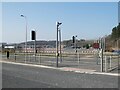
2
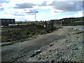
Keep Out
Big galvy gates forming part of this boundary keeps the likes o' you an' me oot.
Disused / Reclaimed land.
Many of the oil storage tanks have been dismantled and removed. Looking toward Rosyth Dockyard.
Image: © Simon Johnston
Taken: 25 Aug 2005
0.15 miles
3

Bridge Material Storage
This is a holding area for materials used in the Queensferry Crossing. The structures at the back are offices and temporary accommodation for construction workers.
Image: © Robert Struthers
Taken: 20 Mar 2015
0.17 miles
4
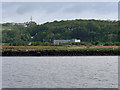
Firth of Forth, near Rosyth
The large building in the centre of the photograph (Image]) is used by the constructors of the new Queensferry Crossing road bridge.
Image: © David Dixon
Taken: 23 May 2017
0.18 miles
5
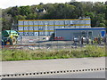
Dragados site offices and compound
On Ferrytoll Road. Dragados is one of the consortium involved in the Forth Replacement Crossing construction.
Image: © M J Richardson
Taken: 6 May 2012
0.19 miles
6
Former constructor's yard
Beyond the light-controlled crossing on King Malcolm Drive is a large constructor's yard formerly used by contractors engaged on the construction of the Queensferry Crossing, now apparently disused.
Image: © Oliver Dixon
Taken: 21 Mar 2022
0.19 miles
7
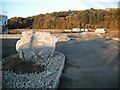
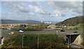
Dunsyre House
Exit from a roundabout. At this time there was no house, just land awaiting development where there was once a tank farm.
Image: © Richard Webb
Taken: 15 Oct 2009
0.19 miles
8
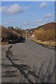
Old Castlandhill Road
This was formerly Castlandhill Road, looking towards Rosyth - it has been bypassed with a new straighter section and is now a lay-by.
Image: © Robert Struthers
Taken: 20 Feb 2010
0.19 miles
9
New road 2
Image This is a view eastwards to the M90 motorway.
Image: © Paul McIlroy
Taken: 20 Apr 2007
0.20 miles
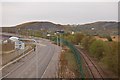
10
View across A90 towards Rosyth Ferry Terminal
From the railway line near Jamestown.
Image: © Stanley Howe
Taken: 17 Apr 2007
0.20 miles