IMAGES TAKEN NEAR TO
Morris Court, INVERKEITHING, KY11 1EF
Introduction
This page details the photographs taken nearby to Morris Court, KY11 1EF by members of the Geograph project.
The Geograph project started in 2005 with the aim of publishing, organising and preserving representative images for every square kilometre of Great Britain, Ireland and the Isle of Man.

There are currently over 7.5m images from over14,400 individuals and you can help contribute to the project by visiting https://www.geograph.org.uk
Image Map
Images are licensed for reuse under creativecommons.org/licenses/by-sa/2.0
Notes
- Clicking on the map will re-center to the selected point.
- The higher the marker number, the further away the image location is from the centre of the postcode.
Image Listing (80 Images Found)
Images are licensed for reuse under creativecommons.org/licenses/by-sa/2.0
Image
Details
Distance
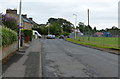
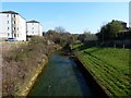
2
Inverkeithing/Fraser Avenue
Council housing built in the 1960s to attract families from Glasgow.
Image: © Paul McIlroy
Taken: 18 Nov 2007
0.13 miles
3

Ballast Bank sports pavilion, Inverkeithing
The home of Inverkeithing Hillfield Swifts F.C.
Image: © M J Richardson
Taken: 4 May 2012
0.13 miles
4
Ballast Bank
By the harbour, with Preston Crescent in the background.
Image: © Thomas Nugent
Taken: 23 Dec 2015
0.14 miles
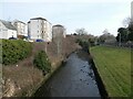
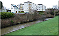
6
Keithing burn
The stream from which the town of Inverkeithing derives its name.
Image: © James Allan
Taken: 26 Mar 2012
0.15 miles
7
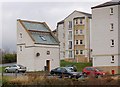
Doocot/House
This dwelling has been built on the site of a ruined Doocot. Image
Image: © Paul McIlroy
Taken: 18 Nov 2007
0.15 miles
8
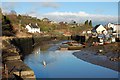
Inverkeithing Harbour
It has been neglected for many years, it is only used by a small amount of pleasure craft.
Image: © Paul McIlroy
Taken: 10 Jan 2007
0.15 miles
9

Two Bridges
The road bridge crosses The Keithing Burn at Preston Crescent and the footbridge spans the now unused railway line to Rosyth Dockyard.
Image: © Paul McIlroy
Taken: 10 Jan 2007
0.16 miles
10
The Keithing Burn
Looking across to Merchant's Way from Preston Crescent. The converted, Category B Listed http://portal.historic-scotland.gov.uk/designation/LB35108 Rosebery Doocot is on the left.
Image: © Thomas Nugent
Taken: 23 Dec 2015
0.16 miles