IMAGES TAKEN NEAR TO
Gray Place, INVERKEITHING, KY11 1DH
Introduction
This page details the photographs taken nearby to Gray Place, KY11 1DH by members of the Geograph project.
The Geograph project started in 2005 with the aim of publishing, organising and preserving representative images for every square kilometre of Great Britain, Ireland and the Isle of Man.

There are currently over 7.5m images from over14,400 individuals and you can help contribute to the project by visiting https://www.geograph.org.uk
Image Map
Images are licensed for reuse under creativecommons.org/licenses/by-sa/2.0
Notes
- Clicking on the map will re-center to the selected point.
- The higher the marker number, the further away the image location is from the centre of the postcode.
Image Listing (53 Images Found)
Images are licensed for reuse under creativecommons.org/licenses/by-sa/2.0
Image
Details
Distance
2
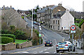
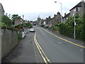
Alma Street
A one way street, a continuation of King Street.
Image: © Thomas Nugent
Taken: 23 Dec 2015
0.09 miles
5
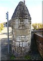
East Port marker stone, King Street
A marker stone indicating the former presence of a port into the Royal Burgh of Inverkeithing. This is the only one of three that has survived.
Image: © kim traynor
Taken: 16 Oct 2011
0.15 miles
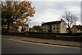
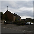
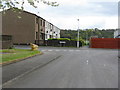
7
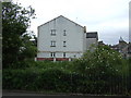
Concorde Way, Inverkeithing
Housing estate on the eastern outskirts of Inverkeithing.
Image: © M J Richardson
Taken: 4 May 2012
0.15 miles
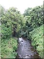
9
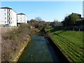
Keithing burn
The stream from which the town of Inverkeithing derives its name.
Image: © James Allan
Taken: 26 Mar 2012
0.15 miles
10
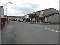
Concorde Way, Inverkeithing
With a path leading through to the edge of the estate and Agnes Paterson Wynd and farmland.
Image: © M J Richardson
Taken: 4 May 2012
0.17 miles