IMAGES TAKEN NEAR TO
Kirk Wynd, ANSTRUTHER, KY10 3TW
Introduction
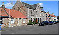
This page details the photographs taken nearby to Kirk Wynd, KY10 3TW by members of the Geograph project.
The Geograph project started in 2005 with the aim of publishing, organising and preserving representative images for every square kilometre of Great Britain, Ireland and the Isle of Man.

There are currently over 7.5m images from over14,400 individuals and you can help contribute to the project by visiting https://www.geograph.org.uk
Image Map
Images are licensed for reuse under creativecommons.org/licenses/by-sa/2.0
Notes
- Clicking on the map will re-center to the selected point.
- The higher the marker number, the further away the image location is from the centre of the postcode.
Image Listing (270 Images Found)
Images are licensed for reuse under creativecommons.org/licenses/by-sa/2.0
Image
Details
Distance
1
Kirk Wynd, Crail, Fife
South east view down Kirk Wynd, Crail, in the East Neuk of Fife, Scotland.
Image: © Jerzy Morkis
Taken: 24 Jun 2020
0.01 miles
2
Kirk Wynd, Crail, Fife
A north west view up Kirk Wynd, towards the road, Crail, in the East Neuk of Fife, Scotland.
Image: © Jerzy Morkis
Taken: 24 Jun 2020
0.01 miles
3
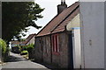
Kirk Wynd
Linking Marketgate with Nethergate. One way street for cars.
Image: © Callum Black
Taken: 6 May 2007
0.03 miles
4
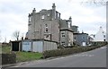
Miramar, Marketgate South
A large house and garages.
Image: © Richard Sutcliffe
Taken: 18 Mar 2019
0.03 miles
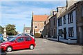
5

Marketgate, Crail
The north end of the Marketgate as it drops to the Denburn.
Image: © Jim Bain
Taken: 22 Sep 2007
0.03 miles
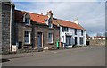
6
Marketgate, Crail
The seaward side of this very broad street.
Image: © Jim Bain
Taken: 22 Sep 2007
0.04 miles
7
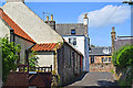
Houses at the end of Nethergate, Crail
Image: © Richard Sutcliffe
Taken: 18 Mar 2019
0.05 miles
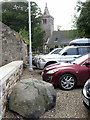
8
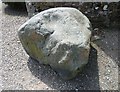
The Bluestane, Crail Parish Kirk
Bluestone boulder at the entrance to the parish kirk, said to have been thrown by the De'il all the war from the Isle of May at the mouth of the Forth to destroy the building of the church. The round indentation is reputedly Auld Nick's thumbprint.
Image: © kim traynor
Taken: 7 Jun 2013
0.05 miles
9
The Blue Stane, Crail
Outside the church gates lies a large boulder called the Blue Stane. This is traditionally said to have been thrown by the devil from the Isle of May when the church was being built. The stone split in mid-air, one piece landing here and the other, larger piece, landing on Balcomie Beach near Fife Ness Image A circular depression on the surface of the stone is said to be the mark of the devil's thumb. Similar stones are considered by geologists to be merely erratics delivered by past glaciers.
The Church was built around the mid 12th century and was consecrated by Bishop De Bernham of St Andrews in 1243. Originally the Church was dedicated to St Maolrubh of Applecross (Rufus the Redhead) but later changed to St Mary when Celtic saints fell out of favour with the Roman Church.
Image: © Andrew Curtis
Taken: 22 Aug 2019
0.05 miles
10
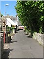
Nethergate North, Crail, Fife
Housing on Nethergate North, Crail, in the East Neuk of Fife, Scotland.
Image: © Jerzy Morkis
Taken: 27 Jun 2020
0.05 miles