IMAGES TAKEN NEAR TO
Castle Street, ANSTRUTHER, KY10 3SH
Introduction
This page details the photographs taken nearby to Castle Street, KY10 3SH by members of the Geograph project.
The Geograph project started in 2005 with the aim of publishing, organising and preserving representative images for every square kilometre of Great Britain, Ireland and the Isle of Man.

There are currently over 7.5m images from over14,400 individuals and you can help contribute to the project by visiting https://www.geograph.org.uk
Image Map
Images are licensed for reuse under creativecommons.org/licenses/by-sa/2.0
Notes
- Clicking on the map will re-center to the selected point.
- The higher the marker number, the further away the image location is from the centre of the postcode.
Image Listing (576 Images Found)
Images are licensed for reuse under creativecommons.org/licenses/by-sa/2.0
Image
Details
Distance
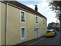
1
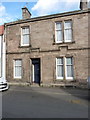
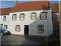
16 Castle Street, Crail
16 Castle Street (and the adjoining no 18 to its right, which was rather obscured by a car on this occasion) is late 19th century town house which was Category C listed https://britishlistedbuildings.co.uk/200359158-16-and-18-castle-street-east-neuk-and-landward-ward#.W_7r9NSLTGg in 1972. The snecked rubble construction and the 'kinked' string course are not typical of other houses around Crail.
Image: © Richard Law
Taken: 5 Oct 2018
0.00 miles
2
20 & 22 Castle Street, Crail
These two early 19th century houses are each subject to a Category C listing https://britishlistedbuildings.co.uk/200359160-20-and-22-castle-street-east-neuk-and-landward-ward#.W_7tSdSLTGg which was granted in 1972; the text reads the same for them both, so they are effectively co-listed.
Image: © Richard Law
Taken: 5 Oct 2018
0.01 miles
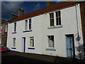
3
'Bruce Cottage' 2 Rose Wynd, Crail
Dating from around 1800, and Category C listed https://britishlistedbuildings.co.uk/200359167-2-rose-wynd-bruce-cottage-east-neuk-and-landward-ward#.W_25NdSLTGg in 1972.
Image: © Richard Law
Taken: 5 Oct 2018
0.01 miles
4
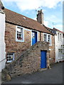
1 Rose Wynd, Crail
No 1 Rose Wynd, with its forestair, dates from the early 18th century, and was Category B listed https://britishlistedbuildings.co.uk/200359166-1-rose-wynd-east-neuk-and-landward-ward#.W_26GdSLTGg in 1972.
Image: © Richard Law
Taken: 5 Oct 2018
0.01 miles
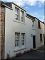
5
12 Castle Street, Crail
Calling itself The Coach House, this is an 18th century 2 storey cottage, and was Category B listed https://britishlistedbuildings.co.uk/200359156-12-castle-street-east-neuk-and-landward-ward#.W_28vtSLTGg in 1972.
Image: © Richard Law
Taken: 5 Oct 2018
0.01 miles
6
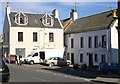
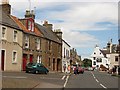
High Street, Crail
Near the eastern end of the High Street.
Image: © Jim Bain
Taken: 22 Sep 2007
0.02 miles
7
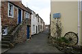
Rose Wynd, Crail
The house with the forestair is Category B listed [http://portal.historicenvironment.scot/designation/LB23418].
The sign reads:
Unsuitable for
Heavy Goods
Vehicles
Image: © Richard Sutcliffe
Taken: 18 Mar 2019
0.02 miles
8
24 Castle Street, Crail
An early 19th century town house, rather striking with its black margins, which was Category C listed https://britishlistedbuildings.co.uk/200359162-24-castle-street-east-neuk-and-landward-ward#.W_7uedSLTGg in 1972. Its neighbour to the right Image looks less severe.
Image: © Richard Law
Taken: 5 Oct 2018
0.02 miles
9
Crail High Street
Looking along the High Street towards a sand sculpture outside the Golf Hotel.
Image: © Richard Webb
Taken: 3 Jul 2010
0.02 miles
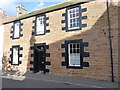
10
10 Castle Street, Crail
No 10 Castle Street is 18th century, and was Category B listed https://britishlistedbuildings.co.uk/200359155-10-castle-street-east-neuk-and-landward-ward#.W_27KtSLTGg in 1972.
Image: © Richard Law
Taken: 5 Oct 2018
0.02 miles