IMAGES TAKEN NEAR TO
St. Andrews Drive, THURSO, KW14 8QA
Introduction
This page details the photographs taken nearby to St. Andrews Drive, KW14 8QA by members of the Geograph project.
The Geograph project started in 2005 with the aim of publishing, organising and preserving representative images for every square kilometre of Great Britain, Ireland and the Isle of Man.

There are currently over 7.5m images from over14,400 individuals and you can help contribute to the project by visiting https://www.geograph.org.uk
Image Map
Images are licensed for reuse under creativecommons.org/licenses/by-sa/2.0
Notes
- Clicking on the map will re-center to the selected point.
- The higher the marker number, the further away the image location is from the centre of the postcode.
Image Listing (18 Images Found)
Images are licensed for reuse under creativecommons.org/licenses/by-sa/2.0
Image
Details
Distance
1
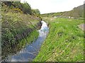
The Mill Lade at Thurso
This lade used to convey water to the mill at Millbank.
Image: © david glass
Taken: 14 May 2010
0.08 miles
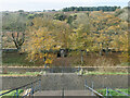
2
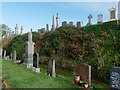
Burials, Mount Vernon Cemetery, Thurso
A number of burials occupy the upper terraces of the burial ground.
Image: © Julian Paren
Taken: 29 Oct 2020
0.09 miles
3
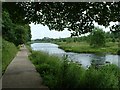
Thurso River Walk
This walk is lovely and is suitable for wheelchairs too! The walk takes you up the river across the cemetery bridge and back down to the top footbridge.
Image: © Dorcas Sinclair
Taken: 30 Jun 2003
0.09 miles
4
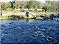
Pontus Fractus
'The Broken Bridge'. All that remains of the footbridge that once straddled the river Thurso at this point, are ramps at either side and a bit of rubble in between. The bridge was washed away by floodwater.
Image: © Bill Henderson
Taken: 28 Sep 2007
0.12 miles

6
The central steps, Mount Vernon Cemetery, Thurso
The cemetery occupies a terrace and a steep bank down to the River Thurso. The bank is cut by platforms and in the middle are steps to the river below. The lower platforms are devoid of burials.
Image: © Julian Paren
Taken: 29 Oct 2020
0.12 miles
7
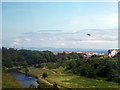
Approaching Thurso
Beside the Thurso River on a Scotrail train heading for Wick.
Image: © John Lucas
Taken: 6 Jul 2005
0.13 miles
8

River Thurso beside The Mall Walk, Thurso
The Mall Walk provides a circular walk along the banks of the River Thurso, and this is from one bank looking towards the hidden footpath on the opposite bank.
Image: © Julian Paren
Taken: 29 Oct 2020
0.14 miles
9
The walls of Mount Vernon Cemetery, Thurso
Behind the walls is a terraced slope awaiting burials. Before the walls is a path of the Mall Walk Project heading to The Salmon Pool on the River Thurso. So close to the centre of Thurso yet a world apart. Less than 30 minutes walk from Thurso Train Station, yet unseen by most Geographers who focus on the "most northerly station" in the UK.
Image: © Julian Paren
Taken: 29 Oct 2020
0.14 miles
10

The Mall Walk, Thurso
Pathways and bridges were constructed during the lifetime of the Mall Walk Project led by Thurso Rotary Club, so that there are all-weather paths out of Thurso on the banks of the River Thurso. This brings the countryside right into the centre of Thurso and its park.
Image: © Julian Paren
Taken: 29 Oct 2020
0.15 miles