IMAGES TAKEN NEAR TO
Merritt Gardens, CHESSINGTON, KT9 2GJ
Introduction
This page details the photographs taken nearby to Merritt Gardens, KT9 2GJ by members of the Geograph project.
The Geograph project started in 2005 with the aim of publishing, organising and preserving representative images for every square kilometre of Great Britain, Ireland and the Isle of Man.

There are currently over 7.5m images from over14,400 individuals and you can help contribute to the project by visiting https://www.geograph.org.uk
Image Map
Images are licensed for reuse under creativecommons.org/licenses/by-sa/2.0
Notes
- Clicking on the map will re-center to the selected point.
- The higher the marker number, the further away the image location is from the centre of the postcode.
Image Listing (14 Images Found)
Images are licensed for reuse under creativecommons.org/licenses/by-sa/2.0
Image
Details
Distance
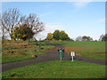
2
Close off Merritt Gardens, Chessington
This area was built in 1998/99 on an area that was mostly open green fields but as it was the grounds of a public building it was not strictly greenbelt, rather 'brownfield' and therefore planning permission was available to build on it.
Image: © Hugh Venables
Taken: 6 Nov 2010
0.08 miles
3
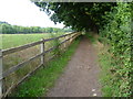
Path to Chessington
This footpath comes from Claygate and passes through The Grapsome, then under the Esher By-pass (A3) before reaching the outskirts of Chessington ahead.
Image: © Marathon
Taken: 25 Sep 2013
0.11 miles
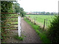
5
Bridleway on the edge of Chessington
This bridleway leaves the path between Chessington and Claygate and runs northwards along the edge of this field, parallel to the Esher By-pass. The bridleway ahead tends to get churned up by horses and as there is no way to avoid the resultant mud in places, an unofficial footpath has been created in the field on the left, next to the bridleway. In this view the Esher By-pass is beyond the trees to the left.
Image: © Marathon
Taken: 25 Sep 2013
0.14 miles
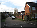
6
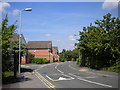
Merritt Gardens, Chessington (2)
The main distributor road through a relatively recent housing development west of Leatherhead Road.
Image: © Richard Vince
Taken: 16 May 2014
0.15 miles
7
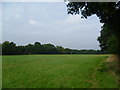
Field on the edge of Chessington
A bridleway leaves Mansfield Road to run southwards along the edge of this field, parallel to the Esher By-pass. The bridleway tends to get churned up by horses and as there is no way to avoid the resultant mud in places, an unofficial footpath has been created in the field next to the bridleway. This view looks back along the unofficial path with the bridleway in the trees to the right. The Esher By-pass is beyond the trees to the left.
Image: © Marathon
Taken: 25 Sep 2013
0.16 miles
8
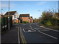
Merritt Gardens, Chessington
This area was built in 1998/99 on an area that was mostly open green fields but as it was the grounds of a public building it was not strictly greenbelt, rather 'brownfield' and therefore planning permission was available to build on it. Merritt gardens was extended into the new development but the OS map at 1:50K hasn't caught up with the change yet.
Image: © Hugh Venables
Taken: 6 Nov 2010
0.17 miles
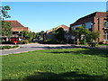
9
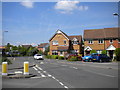
Merritt Gardens, Chessington (1)
The main distributor road through a relatively recent housing development west of Leatherhead Road.
Image: © Richard Vince
Taken: 16 May 2014
0.18 miles
10
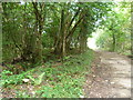
The Grapsome
The Grapsome is a small copse immediately to the west of the Esher By-pass (A3). The Grapsome is believed to be the site of a medieval manor, probably dating from before the Norman Conquest. The name may be of Old English origin, signifying the nick-name of the owner. In medieval times it was called 'Graplingeham', then over the centuries this altered to 'Grapham', then 'Grapson' and finally to 'The Grapsome'. On the First Edition Ordnance Survey Map of 1865, The Grapsome is clearly marked as deciduous woodland, but the present woods are a small fraction of their former size, the most recent reduction being in 1974/5 by the construction of the Esher By-pass through the eastern half.
A bridleway from Chessington passes under the A3 and then through the middle of The Grapsome on its way to Claygate. This view looks away from the bridleway with the woodland of The Grapsome on the left and the embankment of the Esher By-pass to the right.
Image: © Marathon
Taken: 25 Sep 2013
0.22 miles