IMAGES TAKEN NEAR TO
Bridge Road, CHESSINGTON, KT9 2EP
Introduction
This page details the photographs taken nearby to Bridge Road, KT9 2EP by members of the Geograph project.
The Geograph project started in 2005 with the aim of publishing, organising and preserving representative images for every square kilometre of Great Britain, Ireland and the Isle of Man.

There are currently over 7.5m images from over14,400 individuals and you can help contribute to the project by visiting https://www.geograph.org.uk
Image Map
Images are licensed for reuse under creativecommons.org/licenses/by-sa/2.0
Notes
- Clicking on the map will re-center to the selected point.
- The higher the marker number, the further away the image location is from the centre of the postcode.
Image Listing (33 Images Found)
Images are licensed for reuse under creativecommons.org/licenses/by-sa/2.0
Image
Details
Distance
4
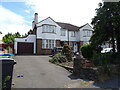
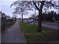
Chessington Court Estate
This view is just round the corner from Chessington North station. It is taken from Station Road with Frimley Road on the left.
Image: © Marathon
Taken: 4 Sep 2013
0.14 miles
6
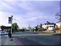
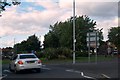
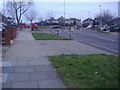
Hook Road during lockdown, May 2020
Looking north towards Hook town centre, from the Chessington end of Hook Road.
Photo taken at about 19.30 on a Monday evening.
Image: © Stefan Czapski
Taken: 18 May 2020
0.15 miles
8
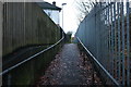
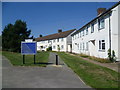
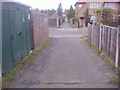
Path from Bridge Road to Church Lane
It runs along the railway line on the right
Image: © David Howard
Taken: 1 Dec 2018
0.16 miles
9
Alleyway behind Hook Road
Crossing Mansfield Road
Image: © David Howard
Taken: 27 Feb 2012
0.16 miles
10
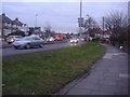
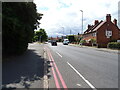
Mansfield Road, Hook
Approaching the roundabout on Hook Road
Image: © David Howard
Taken: 27 Feb 2012
0.16 miles