IMAGES TAKEN NEAR TO
Ewell Road, SURBITON, KT6 7ET
Introduction
This page details the photographs taken nearby to Ewell Road, KT6 7ET by members of the Geograph project.
The Geograph project started in 2005 with the aim of publishing, organising and preserving representative images for every square kilometre of Great Britain, Ireland and the Isle of Man.

There are currently over 7.5m images from over14,400 individuals and you can help contribute to the project by visiting https://www.geograph.org.uk
Image Map
Images are licensed for reuse under creativecommons.org/licenses/by-sa/2.0
Notes
- Clicking on the map will re-center to the selected point.
- The higher the marker number, the further away the image location is from the centre of the postcode.
Image Listing (78 Images Found)
Images are licensed for reuse under creativecommons.org/licenses/by-sa/2.0
Image
Details
Distance
1
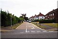
Fairmead, Tolworth
A residential road, off Ewell Road.
Image: © P L Chadwick
Taken: 26 Jul 2015
0.03 miles
2
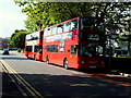
Two London United buses
At Tolworth Towers route 281 to Surbiton.
Image: © Richard Hoare
Taken: 29 Jul 2014
0.04 miles
3
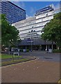
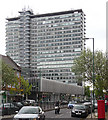
Travelodge (London Chessington), Tolworth Tower, Ewell Road, Tolworth
Travelodge is a national chain of budget hotels. Their Tolworth hotel is, perhaps a tad optimistically, designated Travelodge London Chessington Tolworth Hotel. It is firmly within Tolworth. It occupies the north wing of Tolworth Tower, which is considerably lower than the rest of the building (in Ordnance Survey square TQ1965). Tolworth Tower dates from the early 1960's and was built as offices with shops on the ground floor.
Image
Image: © P L Chadwick
Taken: 18 Aug 2013
0.04 miles
4
Tolworth Travelodge, Ewell road
Situated off the busy A3 route into and out of London.
Image: © Anthony Vosper
Taken: 26 Feb 2012
0.04 miles
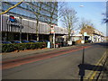
5
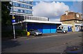
Tolworth Ambulance Station, Ewell Road, Tolworth
Despite the cars parked on the forecourt, this is listed as an active site (as at August 2015) on the London Ambulance Service website. It may be that no vehicles are kept here but personnel clock on and off here, or vehicles may have access to the rear of the building.
Image: © P L Chadwick
Taken: 18 Aug 2013
0.04 miles
6
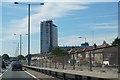
Tolworth Rise South
The A3 at Tolworth.
Image: © Mike Pennington
Taken: 11 Aug 2017
0.04 miles
7
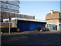
Tolworth, Ambulance Station
Ewell Road. One has the feeling that this is no longer in use.
Tolworth travelodge feature behind.
Image: © Anthony Vosper
Taken: 26 Feb 2012
0.05 miles
8
Tolworth Tower, Ewell Road, Tolworth
Tolworth Tower, with its 22 storeys, dates from the early 1960's. It is used mainly as offices with shops on the ground floor. The North Wing, which is considerably lower, is now used as a Travelodge Hotel. The main block is in Ordnance Survey square TQ1965 but the part occupied by Travelodge is mainly in square TQ1966. This view was taken from Fairmead near its junction with Ewell Road.
Image
Image: © P L Chadwick
Taken: 26 Jul 2015
0.05 miles
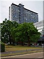
9
Tolworth Tower, Broadway (2)
A notable landmark for some distance around (e.g. Image]) due to it having twenty-two storeys and most of its neighbours two or three. It was designed by Richard Seifert and Partners and built in 1962-64, perhaps an outlier of the large-scale development then ongoing in Croydon (to which Seifert also contributed). See here for a view of the front: Image
Image: © Stephen Richards
Taken: Unknown
0.05 miles
10
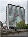
Tolworth Tower, Broadway (1)
A notable landmark for some distance around (e.g. Image]) due to it having twenty-two storeys and most of its neighbours two or three. It was designed by Richard Seifert and Partners and built in 1962-64, perhaps an outlier of the large-scale development then ongoing in Croydon (to which Seifert also contributed). The tower rests on stilts which are splayed at the ends, a feature which Pevsner did not find "aesthetically pleasing". See here for a view of the rear: Image
As can be seen office space is available.
Image: © Stephen Richards
Taken: Unknown
0.05 miles