IMAGES TAKEN NEAR TO
Church Hill Road, SURBITON, KT6 4UG
Introduction
This page details the photographs taken nearby to Church Hill Road, KT6 4UG by members of the Geograph project.
The Geograph project started in 2005 with the aim of publishing, organising and preserving representative images for every square kilometre of Great Britain, Ireland and the Isle of Man.

There are currently over 7.5m images from over14,400 individuals and you can help contribute to the project by visiting https://www.geograph.org.uk
Image Map
Images are licensed for reuse under creativecommons.org/licenses/by-sa/2.0
Notes
- Clicking on the map will re-center to the selected point.
- The higher the marker number, the further away the image location is from the centre of the postcode.
Image Listing (143 Images Found)
Images are licensed for reuse under creativecommons.org/licenses/by-sa/2.0
Image
Details
Distance
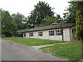
1
Coach House, Church Hill Road, Surbiton
The Coach House is the last surviving building belonging to the original St Mark's Vicarage, c. 1845 [from a parish history website - page since removed]
It is now used as a meeting room for various community groups.
Image: © Stephen Craven
Taken: 6 Aug 2009
0.01 miles
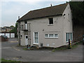
2
St Mark's church hall, Surbiton
The hall is to the west of the church Image and is likely to be demolished in the next few years as part of redevelopment of church properties.
Image: © Stephen Craven
Taken: 6 Aug 2009
0.02 miles
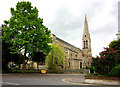
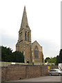
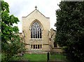
3
St Mark's Church, Surbiton
As with many spired churches, it is difficult to get a good angle on it.
Image: © Bill Boaden
Taken: 12 Sep 2013
0.02 miles
4
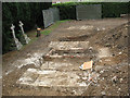
Exposed graves, St Mark's churchyard, Surbiton
Part of the churchyard was being developed in 2009 to provide a new church hall. Victorian graves were being removed by specialist archaeologists in advance of construction work. The coffins were to be re-buried intact in a designated area of Kingston cemetery. See Image for one of the graves after coffins had been removed.
Image: © Stephen Craven
Taken: 6 Aug 2009
0.02 miles
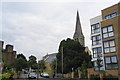
5
Spire of St Mark's church, Surbiton
The western end of the church shown in Image St Mark's was originally built in 1845, but suffered bomb damage in 1940, was rebuilt and re-consecrated on 30 September 1960. http://www.southwark.anglican.org/parishes/270bm2
Image: © Stephen Craven
Taken: 6 Aug 2009
0.02 miles
6
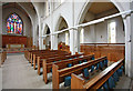
St Mark, St Marks Hill, Surbiton - South arcade
Image: © John Salmon
Taken: 11 May 2010
0.03 miles
7
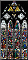
St Mark, St Marks Hill, Surbiton - Window
Image: © John Salmon
Taken: 11 May 2010
0.03 miles
9
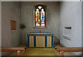
St Mark, St Marks Hill, Surbiton - Lady chapel
Image: © John Salmon
Taken: 11 May 2010
0.03 miles