IMAGES TAKEN NEAR TO
Adelaide Road, SURBITON, KT6 4TA
Introduction
This page details the photographs taken nearby to Adelaide Road, KT6 4TA by members of the Geograph project.
The Geograph project started in 2005 with the aim of publishing, organising and preserving representative images for every square kilometre of Great Britain, Ireland and the Isle of Man.

There are currently over 7.5m images from over14,400 individuals and you can help contribute to the project by visiting https://www.geograph.org.uk
Image Map
Images are licensed for reuse under creativecommons.org/licenses/by-sa/2.0
Notes
- Clicking on the map will re-center to the selected point.
- The higher the marker number, the further away the image location is from the centre of the postcode.
Image Listing (153 Images Found)
Images are licensed for reuse under creativecommons.org/licenses/by-sa/2.0
Image
Details
Distance
1
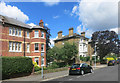
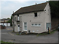
Adelaide Road, Surbiton
A residential street with a mixture of original large houses and subsequent infill.
A public footpath runs between the two houses here, giving a pedestrian shortcut to busier Claremont Road.
Image: © Des Blenkinsopp
Taken: 14 Jul 2016
0.02 miles
2
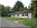
St Mark's church hall, Surbiton
The hall is to the west of the church Image and is likely to be demolished in the next few years as part of redevelopment of church properties.
Image: © Stephen Craven
Taken: 6 Aug 2009
0.05 miles
4

Disused church gate
This gate in the north-west corner of the grounds of St Mark's church hall on Church Hill Road includes the title "St Mark's Church" in the wrought ironwork. It appears not to have been used for decades, judging by how overgrown the path inside it is. The main entrance to the church is now from St Mark's Hill on the other side of the site.
Image: © Stephen Craven
Taken: 6 Aug 2009
0.06 miles
5
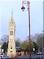
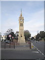
Surbiton Clock Tower
Erected in 1908 to celebrate the coronation of King Edward VII. It stands on Claremont Road, at the south end of the gardens.
Image: © Colin Smith
Taken: 12 Dec 2008
0.06 miles
6
Coach House, Church Hill Road, Surbiton
The Coach House is the last surviving building belonging to the original St Mark's Vicarage, c. 1845 [from a parish history website - page since removed]
It is now used as a meeting room for various community groups.
Image: © Stephen Craven
Taken: 6 Aug 2009
0.07 miles
7
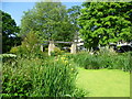
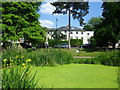
Claremont Gardens
In 1834 an Act for building a railway between London and Southampton received Royal Assent. Local councillors in Kingston, coupled with the coaching interests and Lord Cottenham, owner of much of the land between Kingston and Wimbledon, objected to the railway running through the town, and so the railway was forced to pass a mile and a half to the south. A station opened in 1838 at what was then called “Kingston New Town” or, from 1841, “Kingston-on-Railway”. This was subsequently named Surbiton. The fine houses and good rail service attracted wealthy commuters and earned Surbiton the title of “Queen of the Suburbs”.
This is Claremont Gardens which lies between The Crescent and Claremont Road. The flats behind the trees are in Claremont Road.
Image: © Marathon
Taken: 5 Jun 2013
0.07 miles
9
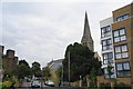
St Mark's Church, Surbiton
As with many spired churches, it is difficult to get a good angle on it.
Image: © Bill Boaden
Taken: 12 Sep 2013
0.08 miles
10
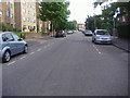
Claremont Gardens
In 1834 an Act for building a railway between London and Southampton received Royal Assent. Local councillors in Kingston, coupled with the coaching interests and Lord Cottenham, owner of much of the land between Kingston and Wimbledon, objected to the railway running through the town, and so the railway was forced to pass a mile and a half to the south. A station opened in 1838 at what was then called “Kingston New Town” or, from 1841, “Kingston-on-Railway”. This was subsequently named Surbiton. The fine houses and good rail service attracted wealthy commuters and earned Surbiton the title of “Queen of the Suburbs”.
This is Claremont Gardens which lies between The Crescent and Claremont Road. The houses seen here are in Claremont Road.
Image: © Marathon
Taken: 5 Jun 2013
0.08 miles