IMAGES TAKEN NEAR TO
Avenue Elmers, SURBITON, KT6 4SJ
Introduction
This page details the photographs taken nearby to Avenue Elmers, KT6 4SJ by members of the Geograph project.
The Geograph project started in 2005 with the aim of publishing, organising and preserving representative images for every square kilometre of Great Britain, Ireland and the Isle of Man.

There are currently over 7.5m images from over14,400 individuals and you can help contribute to the project by visiting https://www.geograph.org.uk
Image Map
Images are licensed for reuse under creativecommons.org/licenses/by-sa/2.0
Notes
- Clicking on the map will re-center to the selected point.
- The higher the marker number, the further away the image location is from the centre of the postcode.
Image Listing (89 Images Found)
Images are licensed for reuse under creativecommons.org/licenses/by-sa/2.0
Image
Details
Distance
1
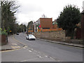
Surbiton Hill Road
With recent housing on the right replacing some old houses on a very narrow plot by the road.
Image: © Hugh Venables
Taken: 26 Dec 2011
0.07 miles
2
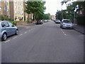
Flats coming?
At the junction between Cranes Park Avenue and Surbiton Hill Road. This area was previously occupied by a house and some single story offices.
Image: © Hugh Venables
Taken: 26 Dec 2011
0.09 miles
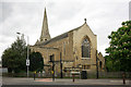
6
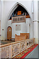
St Mark, St Marks Hill, Surbiton - Organ
Image: © John Salmon
Taken: 11 May 2010
0.12 miles
7

Disused church gate
This gate in the north-west corner of the grounds of St Mark's church hall on Church Hill Road includes the title "St Mark's Church" in the wrought ironwork. It appears not to have been used for decades, judging by how overgrown the path inside it is. The main entrance to the church is now from St Mark's Hill on the other side of the site.
Image: © Stephen Craven
Taken: 6 Aug 2009
0.13 miles
8
St Mark, St Marks Hill, Surbiton - East end
Image: © John Salmon
Taken: 11 May 2010
0.13 miles
9
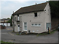
Coach House, Church Hill Road, Surbiton
The Coach House is the last surviving building belonging to the original St Mark's Vicarage, c. 1845 [from a parish history website - page since removed]
It is now used as a meeting room for various community groups.
Image: © Stephen Craven
Taken: 6 Aug 2009
0.13 miles
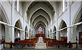
10

St Mark, St Marks Hill, Surbiton - Lady chapel
Image: © John Salmon
Taken: 11 May 2010
0.13 miles