IMAGES TAKEN NEAR TO
Elmbridge Avenue, SURBITON, KT5 9HG
Introduction
This page details the photographs taken nearby to Elmbridge Avenue, KT5 9HG by members of the Geograph project.
The Geograph project started in 2005 with the aim of publishing, organising and preserving representative images for every square kilometre of Great Britain, Ireland and the Isle of Man.

There are currently over 7.5m images from over14,400 individuals and you can help contribute to the project by visiting https://www.geograph.org.uk
Image Map
Images are licensed for reuse under creativecommons.org/licenses/by-sa/2.0
Notes
- Clicking on the map will re-center to the selected point.
- The higher the marker number, the further away the image location is from the centre of the postcode.
Image Listing (83 Images Found)
Images are licensed for reuse under creativecommons.org/licenses/by-sa/2.0
Image
Details
Distance
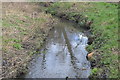
1
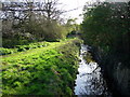
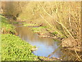
Stream through Berrylands
Tolworth Brook, a tributary of the Hogsmill.
Image: © Hugh Venables
Taken: 8 Apr 2006
0.03 miles
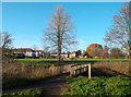
3
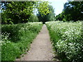
London LOOP at Elmbridge Meadows
Maps of the 19th century show the Hogsmill Valley as a patchwork of fields, those close to the river being meadows whilst arable fields lay further away out of the reach of flooding. The Hogsmill is a chalk stream since most of its water comes from the dip-slope springs at Ewell. At the turn of the 20th century this was still a large area of farmland. It has been saved from development by virtue of being the floodplain of the Hogsmill. It now forms a wildlife corridor followed here through Elmbridge Meadows by the London LOOP on its way to Kingston Bridge. This is looking back upriver towards Old Malden with the river just to the left. Cow parsley was out in profusion either side of the path.
Image: © Marathon
Taken: 5 Jun 2013
0.06 miles
4
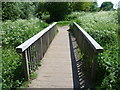
London LOOP at Elmbridge Meadows
Maps of the 19th century show the Hogsmill Valley as a patchwork of fields, those close to the river being meadows whilst arable fields lay further away out of the reach of flooding. The Hogsmill is a chalk stream since most of its water comes from the dip-slope springs at Ewell. At the turn of the 20th century this was still a large area of farmland. It has been saved from development by virtue of being the floodplain of the Hogsmill. It now forms a wildlife corridor followed here through Elmbridge Meadows by the London LOOP on its way to Kingston Bridge. This is looking back upriver towards Old Malden. The footbridge crosses the Tolworth Brook which rises at Claygate. It joins the Hogsmill just to the left. Cow parsley was out in profusion either side of the path.
Image: © Marathon
Taken: 5 Jun 2013
0.06 miles
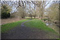
6
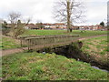
Footbridge at Berrylands
This wooden bridge carries the London LOOP long-distance path across a drainage channel at Berrylands, in the outer suburbs of south west London.
Image: © Malc McDonald
Taken: 17 Feb 2019
0.06 miles
7
Footbridge, Hogsmill River Park
On the London Loop and Hogsmill River Walk close to Berrylands.
www.surbiton.com
Image: © Colin Smith
Taken: 15 Dec 2011
0.06 miles
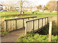
8
Loop Footbridge, Hogsmill River Park
The London Loop long distance path crosses a small tributary of the Hogsmill at the northern end of a pleasant riverside nature reserve section.
Going on from this point the Loop route is mostly urban until you get beyond Kingston.
Image: © Des Blenkinsopp
Taken: 12 Dec 2011
0.06 miles
9
Hogsmill River
Sunny midwinter day in the Hogsmill River Park, between New Malden and Surbiton.
www.surbiton.com
Image: © Colin Smith
Taken: 15 Dec 2011
0.06 miles
10
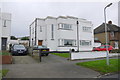
Art Deco Houses Elmbridge Avenue
This is a pair of Art Deco semi detached house on the west side of the street a short distance south of the junction with Grand Avenue.This is a cross rid photo as the easting grid line lies between the photographer and the house.
Image: © Nigel Mykura
Taken: 3 Dec 2015
0.07 miles