IMAGES TAKEN NEAR TO
Chiltern Drive, SURBITON, KT5 8LX
Introduction
This page details the photographs taken nearby to Chiltern Drive, KT5 8LX by members of the Geograph project.
The Geograph project started in 2005 with the aim of publishing, organising and preserving representative images for every square kilometre of Great Britain, Ireland and the Isle of Man.

There are currently over 7.5m images from over14,400 individuals and you can help contribute to the project by visiting https://www.geograph.org.uk
Image Map
Images are licensed for reuse under creativecommons.org/licenses/by-sa/2.0
Notes
- Clicking on the map will re-center to the selected point.
- The higher the marker number, the further away the image location is from the centre of the postcode.
Image Listing (109 Images Found)
Images are licensed for reuse under creativecommons.org/licenses/by-sa/2.0
Image
Details
Distance
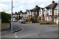
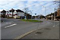
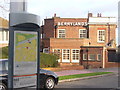
2
Roundabout, Berrylands
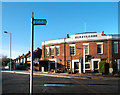
The pub shown in Image is behind the camera. The road ahead is Chiltern Drive.
Image: © Derek Harper
Taken: 29 May 2016
0.06 miles
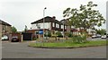
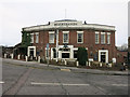
4
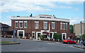
The Berrylands Public House
This Hotel and Pub are near the Berrylands Railway station between Surbiton and New Malden
Image: © steve
Taken: 26 Jun 2005
0.06 miles
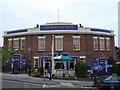
5
Berrylands Bus Stop
Bus stop, with useful local map, beside the Berrylands Hotel, a large pub.
www.surbiton.com
Image: © Colin Smith
Taken: 15 Dec 2011
0.07 miles
6
Berrylands, Berrylands
A pub, Berrylands, in Berrylands. To avoid confusion it's not on Image
Image: © Hugh Venables
Taken: 30 Jan 2015
0.07 miles
7
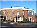
Berrylands
The Berrylands Hotel ("The Berry") is a large pub on the Chiltern Drive roundabout, adjacent to the shops and railway station.
www.surbiton.com
Image: © Colin Smith
Taken: 15 Dec 2011
0.07 miles
8
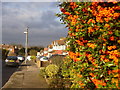
Berries, Berrylands
Bright red berries on The Roystons, a residential street in Berrylands, Surbiton.
www.surbiton.com
Image: © Colin Smith
Taken: 15 Dec 2011
0.07 miles
10
London Loop, Berrylands
The London Loop long distance path stays off-road as much as possible, but where the footpaths don't link up a roadside route has to make do.
One such section is the bit through Berrylands. Here is the green Loop waymark sign in front of the Berrylands pub, which has had a new colour scheme since it was last Geographed in 2005. Image
Image: © Des Blenkinsopp
Taken: 12 Dec 2011
0.08 miles