IMAGES TAKEN NEAR TO
The Avenue, SURBITON, KT5 8JS
Introduction
This page details the photographs taken nearby to The Avenue, KT5 8JS by members of the Geograph project.
The Geograph project started in 2005 with the aim of publishing, organising and preserving representative images for every square kilometre of Great Britain, Ireland and the Isle of Man.

There are currently over 7.5m images from over14,400 individuals and you can help contribute to the project by visiting https://www.geograph.org.uk
Image Map
Images are licensed for reuse under creativecommons.org/licenses/by-sa/2.0
Notes
- Clicking on the map will re-center to the selected point.
- The higher the marker number, the further away the image location is from the centre of the postcode.
Image Listing (21 Images Found)
Images are licensed for reuse under creativecommons.org/licenses/by-sa/2.0
Image
Details
Distance
1
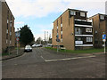
Berrylands, Berrylands
Gregory Court, the road and area are both called Berrylands.
Image: © Hugh Venables
Taken: 30 Jan 2015
0.03 miles
3
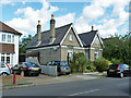
Regent Cottage, Berrylands
A survivor from the late Victorian Regent House grounds, which are otherwise now covered in suburban housing. From its position on old maps, it could have been the gardener's cottage.
Image: © Robin Webster
Taken: 26 Aug 2012
0.12 miles
4
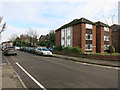
Manor Crescent, Berrylands
Classic suburbia.
Image: © Hugh Venables
Taken: 30 Jan 2015
0.13 miles
5
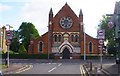
Christ Church Surbiton Hill (1), King Charles Road, Surbiton
The church is an Anglican one, although that fact isn't very obvious on its own website, as far as I can see. It comes under the Diocese of Southwark and was built in 1863 and soon extended. Now it needs further space and improvement so a large fundraising effort is underway. This view was taken from Britannia Road.
Image
Image: © P L Chadwick
Taken: 18 Aug 2013
0.14 miles
7
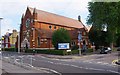
Christ Church Surbiton Hill (2), King Charles Road, Surbiton
A large Anglican church dating from 1863, on the corner of King Charles Road and Christ Church Road.
Image
Image: © P L Chadwick
Taken: 18 Aug 2013
0.15 miles
9
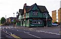
The Castle (1), 108 King Charles Road, Surbiton
Large public house on the corner of King Charles Road and Britannia Road. In the past it was a Watney's house. The parts nearest the camera are in Ordnance Survey square TQ1867, the section further along King Charles Road is in square TQ1866.
Image
Image: © P L Chadwick
Taken: 18 Aug 2013
0.15 miles
10
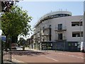
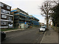
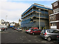
New development King Charles' Road
Image: © Oast House Archive
Taken: 7 Aug 2018
0.16 miles