IMAGES TAKEN NEAR TO
Minstrel Gardens, SURBITON, KT5 8DD
Introduction
This page details the photographs taken nearby to Minstrel Gardens, KT5 8DD by members of the Geograph project.
The Geograph project started in 2005 with the aim of publishing, organising and preserving representative images for every square kilometre of Great Britain, Ireland and the Isle of Man.

There are currently over 7.5m images from over14,400 individuals and you can help contribute to the project by visiting https://www.geograph.org.uk
Image Map
Images are licensed for reuse under creativecommons.org/licenses/by-sa/2.0
Notes
- Clicking on the map will re-center to the selected point.
- The higher the marker number, the further away the image location is from the centre of the postcode.
Image Listing (49 Images Found)
Images are licensed for reuse under creativecommons.org/licenses/by-sa/2.0
Image
Details
Distance
2
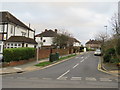
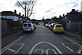
Eversley Road, near Kingston-upon-Thames
Eversley Road is a residential road in the outer suburbs of south west London.
Image: © Malc McDonald
Taken: 17 Feb 2019
0.13 miles
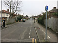
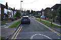
4
Villiers Avenue
One of the main links between Surbiton and Kingston. The speed humps are annoying but cars did drive too fast down here and Cranes Park before they were put in.
Image: © Hugh Venables
Taken: 31 Dec 2011
0.14 miles
7
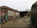
Boarded up building
Off Lower Marsh Lane.
Image: © Hugh Venables
Taken: 30 Jan 2015
0.15 miles
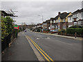
8
Villiers Close, near Kingston-upon-Thames
Villiers Close is a residential cul-de-sac in the outer suburbs of south west London.
Image: © Malc McDonald
Taken: 17 Feb 2019
0.15 miles
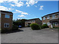
9

Addison Gardens, near Kingston
Addison Gardens is a residential cul-de-sac near Kingston-upon-Thames, in the south west suburbs of south west London.
Image: © Malc McDonald
Taken: 17 Feb 2019
0.16 miles
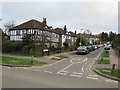
10
Deflated Santa
The junction of Addison Gardens with Lower Marsh Lane.
The footway on the left is part of the London Loop long distance path which follows the Hogsmill River for much of the way between Kingston and Ewell but here has quite a long roadside section where access to the river is closed by a large sewage works.
Hope Santa gets his breath back for Christmas.
Image: © Des Blenkinsopp
Taken: 12 Dec 2011
0.16 miles