IMAGES TAKEN NEAR TO
Chelsea Close, WORCESTER PARK, KT4 7SF
Introduction
This page details the photographs taken nearby to Chelsea Close, KT4 7SF by members of the Geograph project.
The Geograph project started in 2005 with the aim of publishing, organising and preserving representative images for every square kilometre of Great Britain, Ireland and the Isle of Man.

There are currently over 7.5m images from over14,400 individuals and you can help contribute to the project by visiting https://www.geograph.org.uk
Image Map
Images are licensed for reuse under creativecommons.org/licenses/by-sa/2.0
Notes
- Clicking on the map will re-center to the selected point.
- The higher the marker number, the further away the image location is from the centre of the postcode.
Image Listing (8 Images Found)
Images are licensed for reuse under creativecommons.org/licenses/by-sa/2.0
Image
Details
Distance

2
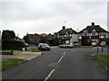
Bargate Close
1930s houses at the junction of Ancaster Crescent in Motspur Park.
Image: © Burgess Von Thunen
Taken: 13 Oct 2011
0.11 miles
3
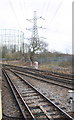
Electricity pylon and gas holders at railway junction
The junction is south of Motspur Park Station
Image: © Roger Templeman
Taken: 7 Feb 2015
0.14 miles
4
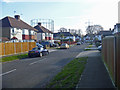
Bargate Close, Malden
Suburban commuterland.
Image: © John Allan
Taken: 11 Mar 2015
0.14 miles
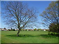
5
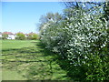
Hawthorn blossom at Manor Park Recreation Ground
Much of Manor Park Recreation Ground consists of playing fields, surrounded by the remains of old hedgerows, indicating their past agricultural use. In 1839 they were shown as arable fields. One of the old hedgerows here is colourful with spring hawthorn blossom. The houses beyond are in Portland Avenue.
Image: © Marathon
Taken: 1 May 2013
0.15 miles
6
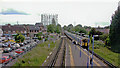
South from Motspur Park station, 2004
View towards Epsom, Leatherhead and Horsham on the ex-LSWR line from Waterloo, also the 1929 branch to Chessington South, which curves to the right in the far distance. The Up train is crossing West Barnes Lane on the level.
Image: © Ben Brooksbank
Taken: 25 Aug 2004
0.16 miles
7
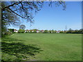
Manor Park Recreation Ground
Much of Manor Park Recreation Ground consists of playing fields, surrounded by the remains of old hedgerows, indicating their past agricultural use. In 1839 they were shown as arable fields. The houses in the distance here are in Portland Avenue and beyond can be seen the gasholders at Motspur Park next to Sir Joseph Hood Wood.
Image: © Marathon
Taken: 1 May 2013
0.24 miles
8
Manor Park Recreation Ground
Much of Manor Park Recreation Ground consists of playing fields, surrounded by the remains of old hedgerows, indicating their past agricultural use. In 1839 they were shown as arable fields.
Image: © Marathon
Taken: 1 May 2013
0.25 miles