IMAGES TAKEN NEAR TO
West Barnes Lane, NEW MALDEN, KT3 6PE
Introduction
This page details the photographs taken nearby to West Barnes Lane, KT3 6PE by members of the Geograph project.
The Geograph project started in 2005 with the aim of publishing, organising and preserving representative images for every square kilometre of Great Britain, Ireland and the Isle of Man.

There are currently over 7.5m images from over14,400 individuals and you can help contribute to the project by visiting https://www.geograph.org.uk
Image Map (Loading...)


Getting Data...Please wait
Leaflet Map data © OpenStreetMap
Images are licensed for reuse under creativecommons.org/licenses/by-sa/2.0
Notes
- Clicking on the map will re-center to the selected point.
- The higher the marker number, the further away the image location is from the centre of the postcode.
Image Listing (50 Images Found)
Images are licensed for reuse under creativecommons.org/licenses/by-sa/2.0
Image
Details
Distance
1
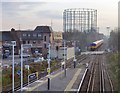
View south from Motspur Park station
A southbound train has just left the station, heading towards Epsom.
The line from Wimbledon to Epsom was built by the London & South Western Railway in 1859. When first opened, there were only two stations on this stretch: 'Old Malden & Worcester Park', and 'Ewell' - subsequently renamed Worcester Park and Ewell West, respectively. The station at Motspur Park was not built until 1925 (by the Southern Railway), reflecting the lateness of residential development in this area. (Information from Dendy Marshall's book 'A History of the Southern Railway').
Beyond the gas-holders a branch line forks west, towards Chessington.
Image: © Stefan Czapski
Taken: 30 Nov 2012
0.03 miles
2
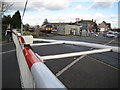
West Barnes: West Barnes Lane level crossing
With typically six trains an hour in each direction on weekdays this is a very busy level crossing with frequent closures to road traffic. Image is in the distance with an up South West Trains train in the station and a down service bound for Dorking departing and about to cross over the level crossing.
Image: © Nigel Cox
Taken: 30 Jan 2008
0.04 miles
3
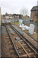
Charter train on level crossing south of Motspur Station
Image: © Roger Templeman
Taken: 7 Feb 2015
0.04 miles
4

Old Boundary Marker by West Barnes Lane, New Maldon parish
Parish Boundary Marker by the UC road, in parish of New Maldon (Kingston upon Thames District), West Barnes Lane, against Northwest parapet of bridge over Beverley Brook.
Inscription reads:-
: MALDEN AND COOMBE : : BOUNDARY : : MERTON AND MORDEN :
Surveyed
Milestone Society National ID: SY_MALC02pb
Image: © Milestone Society
Taken: Unknown
0.05 miles
5

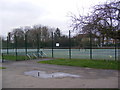
Tennis Courts
At Sir Joseph Hood Memorial Playing Field
Image: © Geographer
Taken: 1 Mar 2011
0.07 miles
6

Tennis Courts
At Sir Joseph Hood Memorial Playing Field
Image: © Geographer
Taken: 1 Mar 2011
0.07 miles
7
Tennis Courts
At Sir Joseph Hood Memorial Playing Field
Image: © Geographer
Taken: 1 Mar 2011
0.07 miles
8
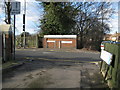
West Barnes: West Barnes Lane and Motspur Park
The grubby white post against the bridge parapet is a boundary marker. It shows the boundary between the former Boroughs of Malden and Coombe to the left and Merton and Morden to the right. During the reorganization of local government in the 1960s, the former became part of the London Borough of Kingston upon Thames, and the latter became part of the London Borough of Merton. The current boundary between these Boroughs still follows the original line through the marker.
The sign on the post on the left shows that you are entering the Royal Borough of Kingston upon Thames. The road changes its name from Motspur Park to West Barnes Lane either side of the boundary post. The bridge carries the road over Beverley Brook.
Image: © Nigel Cox
Taken: 30 Jan 2008
0.07 miles
9
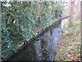
Beverley Brook in Motspur Park
Beverley Brook flows out into the River Thames to the east of Barnes. This was taken looking downstream from the Motspur Park / West Barnes Lane road bridge. The boundary between the London Boroughs of Merton, to the right, and Kingston upon Thames, to the left, runs down the centre of the brook at this location.
Image: © Nigel Cox
Taken: 30 Jan 2008
0.07 miles
10
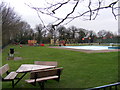
Padling Pool & Children Play Area
At Sir Joseph Hood Memorial Playing Field
Image: © Geographer
Taken: 1 Mar 2011
0.08 miles