IMAGES TAKEN NEAR TO
Richmond Road, KINGSTON UPON THAMES, KT2 5DH
Introduction
This page details the photographs taken nearby to Richmond Road, KT2 5DH by members of the Geograph project.
The Geograph project started in 2005 with the aim of publishing, organising and preserving representative images for every square kilometre of Great Britain, Ireland and the Isle of Man.

There are currently over 7.5m images from over14,400 individuals and you can help contribute to the project by visiting https://www.geograph.org.uk
Image Map
Images are licensed for reuse under creativecommons.org/licenses/by-sa/2.0
Notes
- Clicking on the map will re-center to the selected point.
- The higher the marker number, the further away the image location is from the centre of the postcode.
Image Listing (67 Images Found)
Images are licensed for reuse under creativecommons.org/licenses/by-sa/2.0
Image
Details
Distance
2
Albany Park Canoeing and Sailing Centre, Lower Ham Rd
Run by Kingston Borough Council. http://www.kingston.gov.uk/browse/leisure/albanypark.htm
Image: © N Chadwick
Taken: 25 Aug 2010
0.07 miles
3
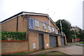
Kingston Sea Cadets Boathouse, Lower Ham Rd
Image: © N Chadwick
Taken: 25 Aug 2010
0.08 miles
4
Tiffin Girl's School, Kingston
The modern part on the right replaced the half burnt by a fire a few years before, it originally matched the other side.
Image: © David Howard
Taken: 22 Dec 2013
0.08 miles
5
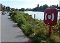
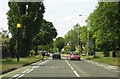
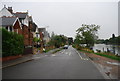
Lower Ham Road in Kingston-upon-Thames
On the east bank of the River Thames.
Image: © Mat Fascione
Taken: 21 Aug 2015
0.09 miles
6
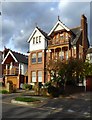
Houses in the Lower Ham Road, Kingston
Houses here overlook the river, and the photo was taken from the river bank. The house in the picture stands close to the point where the road reaches the riverside - if you approach from Ham, that is.
A few houses in the row have kept their original timber-work - the one in the picture being perhaps the least altered. The little house to the left appears to be a converted coach-house.
Image: © Stefan Czapski
Taken: 3 Oct 2017
0.10 miles
7
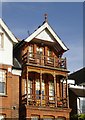
House in the Lower Ham Road, Kingston: detail
A closer look at the timber-work seen in: Image
Image: © Stefan Czapski
Taken: 3 Oct 2017
0.10 miles
9
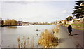
Lower Ham Rd, Kingston
Route of the Thames path.
Image: © N Chadwick
Taken: 25 Aug 2010
0.10 miles
10
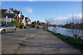
By the Thames at Lower Ham Road
Lower Ham Road, Kingston looking downstream towards Teddington Lock in 1991. The former Hawker Siddeley works is just discernible beyond the curve in the river bank.
Image: © Stephen Williams
Taken: 3 Mar 1991
0.11 miles