IMAGES TAKEN NEAR TO
Crocknorth Road, LEATHERHEAD, KT24 5TG
Introduction
This page details the photographs taken nearby to Crocknorth Road, KT24 5TG by members of the Geograph project.
The Geograph project started in 2005 with the aim of publishing, organising and preserving representative images for every square kilometre of Great Britain, Ireland and the Isle of Man.

There are currently over 7.5m images from over14,400 individuals and you can help contribute to the project by visiting https://www.geograph.org.uk
Image Map
Images are licensed for reuse under creativecommons.org/licenses/by-sa/2.0
Notes
- Clicking on the map will re-center to the selected point.
- The higher the marker number, the further away the image location is from the centre of the postcode.
Image Listing (30 Images Found)
Images are licensed for reuse under creativecommons.org/licenses/by-sa/2.0
Image
Details
Distance
1
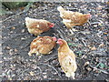
Brooding Hens
Crocknorth Farm - free range hens sitting on eggs in the loose earth by the footpath.
Image: © Colin Smith
Taken: 13 Oct 2007
0.03 miles
2
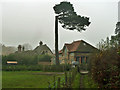
Crocknorth House
The house is the further building towards the left. Straight ahead is a newer house in the grounds.
Image: © Robin Webster
Taken: 22 Nov 2011
0.06 miles
3
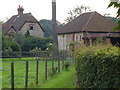
Crocknorth Farm
This flint-walled farm was formerly named Cracknutt Farm. It was drastically redesigned by Lord Lovelace after he bought it in 1840.
Image: © Colin Smith
Taken: 9 Sep 2007
0.06 miles
5
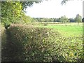
Path beside a meadow
Like a number of meadows in this area it is used mainly to graze horses. Kiln Field Coppice, suggesting lime kiln works, is in the background
Image: © Pip Rolls
Taken: 22 Oct 2005
0.11 miles
7
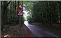
Crocknorth Road - Steep Hill 10%
Crocknorth Road, East Horsley. 10% steep hill down sign.
Image: © Adam Morse
Taken: 6 Jul 2009
0.13 miles
8
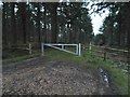
Bridleway with arch, Briary Hill, Dick Focks Common
The arch seen here is situated perhaps 150m to the east of the arch shown in: http://www.geograph.org.uk/photo/4052543 It does not seem to have been plotted on recent OS sheets, but appears to be the arch known locally as Briary Hill East.
This shot shows the approach along the bridleway - which runs in a fairly narrow trench a few feet below the level of the surrounding woodland floor.
Image: © Stefan Czapski
Taken: 30 Jun 2014
0.14 miles
9
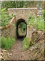
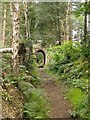
Bridleway and arch, Briary Hill, Dick Focks Common
A closer view of the arch seen in Image As can be seen, the bridleway runs in a narrow trench a few feet below the local ground level. The arch itself is brick lined, whereas much of the structure is built of flint cobbles - whole flint nodules, unknapped.
The bridge is known locally as Briary Hill East, and stands perhaps 120m east of the bridge shown in: http://www.geograph.org.uk/photo/4052543
Image: © Stefan Czapski
Taken: 30 Jun 2014
0.14 miles
10
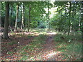
Hanger's Wood
Typical of the woodland with many Beech Trees on the classic Clay with Flints of the North Downs.
Image: © Pip Rolls
Taken: 22 Oct 2005
0.16 miles