IMAGES TAKEN NEAR TO
Cobham Road, LEATHERHEAD, KT22 9JR
Introduction
This page details the photographs taken nearby to Cobham Road, KT22 9JR by members of the Geograph project.
The Geograph project started in 2005 with the aim of publishing, organising and preserving representative images for every square kilometre of Great Britain, Ireland and the Isle of Man.

There are currently over 7.5m images from over14,400 individuals and you can help contribute to the project by visiting https://www.geograph.org.uk
Image Map
Images are licensed for reuse under creativecommons.org/licenses/by-sa/2.0
Notes
- Clicking on the map will re-center to the selected point.
- The higher the marker number, the further away the image location is from the centre of the postcode.
Image Listing (45 Images Found)
Images are licensed for reuse under creativecommons.org/licenses/by-sa/2.0
Image
Details
Distance
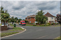
1
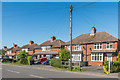
Cobham Road
1930s houses in Cobham Road.
Image: © Ian Capper
Taken: 26 May 2017
0.01 miles
2
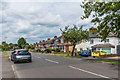
Cobham Road
1930s housing on Cobham Road.
Image: © Ian Capper
Taken: 10 Jul 2019
0.02 miles
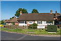
3
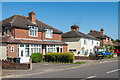
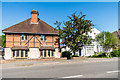
Cobham Road
Mainly 1930s houses in Cobham Road. The 1869 1:2500 map suggests that the white house is on the site of an earlier building (although set further back from the road than the present building), and so it could have been built separately from its neighbours, hence the different design.
Image: © Ian Capper
Taken: 26 May 2017
0.02 miles
4
Cobham Road
Pair of houses houses in Cobham Road. The 1869 1:2500 map shows an isolated building on the site of the one on the left (nos 198-200), long predating the 1930s development of this section of the road - the present building is either the original (presumably refurbished) or a later replacement. The white house to its right (nos 194-196) is also of different design from the rest of the road, being built with a "Dutch roof".
Image: © Ian Capper
Taken: 26 May 2017
0.06 miles
5
Cobham Road
1930s housing on Cobham Road.
Image: © Ian Capper
Taken: 10 Jul 2019
0.07 miles
6
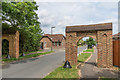
Cannon Grove
Entrance to Cannon Grove off Cobham Road, an area mainly developed in the 1930s, although the initial section on the left, as seen here, was later, being left vacant until the c1980s.
Image: © Ian Capper
Taken: 10 Jul 2019
0.10 miles
7
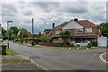
Cannon Grove
Housing at the junction of Cannon Grove with Nutcroft Grove, an area initially developed in the 1930s.
Image: © Ian Capper
Taken: 10 Jul 2019
0.10 miles
8
Nutcroft Grove
Housing at the junction of Cannon Grove with Nutcroft Grove, an area initially developed in the 1930s.
Image: © Ian Capper
Taken: 10 Jul 2019
0.10 miles
9
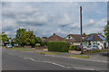
Pound Crescent
Late 1950s/early 1960s housing built on the land of Pound Farm.
Image: © Ian Capper
Taken: 26 May 2017
0.10 miles