IMAGES TAKEN NEAR TO
Downs Lane, LEATHERHEAD, KT22 8JG
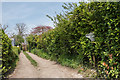
Introduction
This page details the photographs taken nearby to Downs Lane, KT22 8JG by members of the Geograph project.
The Geograph project started in 2005 with the aim of publishing, organising and preserving representative images for every square kilometre of Great Britain, Ireland and the Isle of Man.

There are currently over 7.5m images from over14,400 individuals and you can help contribute to the project by visiting https://www.geograph.org.uk
Image Map
Images are licensed for reuse under creativecommons.org/licenses/by-sa/2.0
Notes
- Clicking on the map will re-center to the selected point.
- The higher the marker number, the further away the image location is from the centre of the postcode.
Image Listing (46 Images Found)
Images are licensed for reuse under creativecommons.org/licenses/by-sa/2.0
Image
Details
Distance
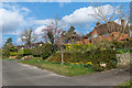
1
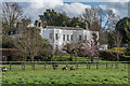
Vale Lodge
House on Downs Lane, but more visible from Dorking Road, as seen here. Built around 1780 on the site of the former rectory. Now subdivided into 4 apartments. Grade II listed - see www.historicengland.org.uk/listing/the-list/list-entry/1378203.
Image: © Ian Capper
Taken: 12 Mar 2020
0.02 miles
2
Downs Lane Leatherhead
Although shown as a through road on maps this actually ends in a bridleway and not open to through traffic.
Image: © David Howard
Taken: 7 Feb 2010
0.02 miles
3
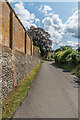
The Driftway
A bridleway (this section also an access track) linking Downs Way with Reigate road, with the central section now forming part of Windmill Drive. The wall was originally that of Oldhouse Farm, shown as such on the 1869-82 1:2500 map, which also marked Downs Lane as Oldhouse Lane.
Image: © Ian Capper
Taken: 30 Apr 2019
0.07 miles
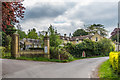
4
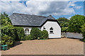
Leedom Lodge
Late 19th Century lodge where Worple Road meets The Driftway, although to what property it was the lodge is not clear.
Image: © Ian Capper
Taken: 13 Aug 2019
0.09 miles
5
Worple Road
The southern end of Worple Road, a track between The Driftway with Church Road, which long predated any development in the area. Note the (broken) "Bridleway No Motor Vehicles" sign; there is a similar (complete) one at the other end - see Image Although the sign suggests that this is a bridleway, the Surrey County Council Rights of Way map marks it as a footpath, FP57.
Image: © Ian Capper
Taken: 18 Apr 2019
0.09 miles
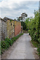
6
Downs Lane
Looking along Downs Lane towards Downside Court. The wall on the left was originally that of Oldhouse Farm, shown as such on the 1869-82 1:2500 map, which also marked Downs Lane as Oldhouse Road.
Image: © Ian Capper
Taken: 13 Aug 2019
0.09 miles
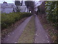
7
Downs Lane
Looking north along Downs Lane. The wall was originally that of Oldhouse Farm, shown as such on the 1869-82 1:2500 map, which also marked Downs Lane as Oldhouse Road.
Image: © Ian Capper
Taken: 30 Apr 2019
0.10 miles
8
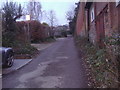
Bridleway Leatherhead
Linking Downs Lane and Worple Road
Image: © David Howard
Taken: 7 Feb 2010
0.10 miles
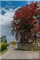
9
St Mary's Road
Upmarket road developed after 1924, when the 21½ acre grounds of Elm Bank House were sold off.
Image: © Ian Capper
Taken: 12 Mar 2020
0.10 miles
10
Downside Court
Former outbuildings to Downside Manor, now converted into housing. In the cleared area of wall on the right can be seen the Victorian postbox in Image
Image: © Ian Capper
Taken: 30 Apr 2019
0.10 miles