IMAGES TAKEN NEAR TO
Emlyn Lane, LEATHERHEAD, KT22 7EP
Introduction
This page details the photographs taken nearby to Emlyn Lane, KT22 7EP by members of the Geograph project.
The Geograph project started in 2005 with the aim of publishing, organising and preserving representative images for every square kilometre of Great Britain, Ireland and the Isle of Man.

There are currently over 7.5m images from over14,400 individuals and you can help contribute to the project by visiting https://www.geograph.org.uk
Image Map
Images are licensed for reuse under creativecommons.org/licenses/by-sa/2.0
Notes
- Clicking on the map will re-center to the selected point.
- The higher the marker number, the further away the image location is from the centre of the postcode.
Image Listing (448 Images Found)
Images are licensed for reuse under creativecommons.org/licenses/by-sa/2.0
Image
Details
Distance
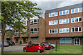
1
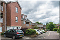
St John House
Apartment block built around 2004 on Emlyn Lane. For some years previously the site had included a St John's Ambulance station.
Image: © Ian Capper
Taken: 11 Jun 2019
0.00 miles
2
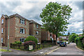
Haydon Court
Apartment block on Emlyn Lane, completed in 1995.
Image: © Ian Capper
Taken: 11 Jun 2019
0.01 miles
3
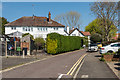
Emlyn Lane
Looking up Emlyn Lane to its corner with Belmont Road. Old maps show the road to have been called River Lane, with the route originally being a footpath.
Image: © Ian Capper
Taken: 11 Apr 2019
0.01 miles
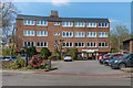
4
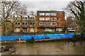
James House and Claire House
1970s office buildings alongside the River Mole, seen here with temporary flood barriers in place following a flood warning covering the River Mole.
Image: © Ian Capper
Taken: 21 Dec 2019
0.02 miles
5
James House and Claire House
1970s office buildings on Emlyn Lane.
Image: © Ian Capper
Taken: 7 Aug 2019
0.02 miles
6
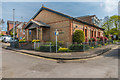
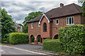
Kingdom Hall
Jehovah's Witness Kingdom Hall in Emlyn Lane.
Image: © Ian Capper
Taken: 18 Apr 2019
0.02 miles
7
Claire House
1970s office building on Bridge Street.
Image: © Ian Capper
Taken: 11 Apr 2019
0.03 miles
8
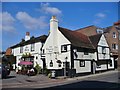
Leatherhead - The Running Horse
Historic pub (1403) beside the Town Bridge.
Image: © Colin Smith
Taken: 28 Sep 2015
0.03 miles
9
Holly Court
Retirement housing on Emlyn Lane/Belmont Road completed in 1987. From 1926 to 1969 the part facing onto Emlyn Lane (as seen here) was the site of Leatherhead Fire Station. The name would seem to come from that of a house in Belmont Road, demolished for the development, called The Hollies.
Image: © Ian Capper
Taken: 11 Jun 2019
0.03 miles
10
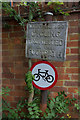
No cycling
Leatherhead Urban District Council "no cycling" sign above a more recent pictorial version at the southern end of the footpath linking Belmont Road/Emlyn Lane to Station Road (see Image). There used to be a similar pair at the northern end of the path (see Image) but in 2019 only the pictorial one remained.
Image: © Ian Capper
Taken: 11 Jun 2019
0.03 miles