IMAGES TAKEN NEAR TO
Queens Drive, LEATHERHEAD, KT22 0PH
Introduction
This page details the photographs taken nearby to Queens Drive, KT22 0PH by members of the Geograph project.
The Geograph project started in 2005 with the aim of publishing, organising and preserving representative images for every square kilometre of Great Britain, Ireland and the Isle of Man.

There are currently over 7.5m images from over14,400 individuals and you can help contribute to the project by visiting https://www.geograph.org.uk
Image Map
Images are licensed for reuse under creativecommons.org/licenses/by-sa/2.0
Notes
- Clicking on the map will re-center to the selected point.
- The higher the marker number, the further away the image location is from the centre of the postcode.
Image Listing (22 Images Found)
Images are licensed for reuse under creativecommons.org/licenses/by-sa/2.0
Image
Details
Distance
1
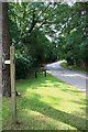
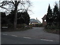
Queen's Drive
View south along Queen's Drive, from the junction with Stokesheath Road (North). These are both private roads, but both are also a public bridleway Esher 90, which gives access between Prince's Coverts and Oxshott Heath without the need to negotiate the busy Fairoak Lane/Warren Lane junction.
Image: © Hugh Craddock
Taken: 9 Jul 2011
0.06 miles
2
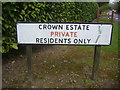
Crown Estate sign, Stokes Heath Road
Most of the residential roads in the east side of Oxshott are part of the crown estate, some accessible to the public and others locked off.
Image: © David Howard
Taken: 25 Apr 2010
0.08 miles
3
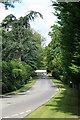
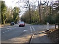
Queen's Drive
Queen's Drive, looking west to the junction with Copsem Lane, seen from the junction with Stokesheath Road North. Both Queen's Drive and Stokesheath Road are private roads on the Crown Estate development.
Image: © Hugh Craddock
Taken: 9 Jul 2011
0.09 miles
6
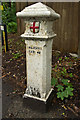
Coal Tax Post no 110
This Coal Tax Post (no 110 on the list linked to below) is situated at the junction of Sandy Lane with Copsem Lane/Warren Lane. For wider view, see Image
Image: © Ian Capper
Taken: 14 Sep 2013
0.14 miles
7
Sandy Lane
Sandy Lane at its junction with Copsem Lane/Warren Lane. For a close up of the coal tax post on the left, see Image
Image: © Ian Capper
Taken: 14 Sep 2013
0.15 miles
8
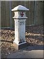
City Corporation Coal Tax Post, at the junction of Sandy Lane and Copsem Lane
This post stands close to a busy road and - as a consequence - was in grubby condition when photographed.
These posts date from the mid 19th century, when the City of London Corporation imposed a tax on coal (and other goods) entering the metropolitan area. They were placed at points on the boundary of that area - though the locations chosen seem pretty arbitrary.
A similar post is to be found a few hundred yards north, where Copsem Lane reaches the A3 roundabout.
Image: © Stefan Czapski
Taken: 5 Mar 2013
0.15 miles
9

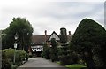
The Grange
One of a group of large houses on Copsem Lane. Locally listed.
Image: © Ian Capper
Taken: 14 Sep 2013
0.16 miles
10
Junction of Sandy Lane with Copsem Lane, showing location of a Coal Tax post
View southwards. The Coal Tax post stands at the corner where Sandy Lane meets Copsem Lane (which continues south as Warren Lane).
For a closer view of the Coal Tax post (and a note on their history), see: http://www.geograph.org.uk/photo/3358931
Image: © Stefan Czapski
Taken: 5 Mar 2013
0.16 miles