IMAGES TAKEN NEAR TO
Broomfield Ride, LEATHERHEAD, KT22 0LR
Introduction
This page details the photographs taken nearby to Broomfield Ride, KT22 0LR by members of the Geograph project.
The Geograph project started in 2005 with the aim of publishing, organising and preserving representative images for every square kilometre of Great Britain, Ireland and the Isle of Man.

There are currently over 7.5m images from over14,400 individuals and you can help contribute to the project by visiting https://www.geograph.org.uk
Image Map
Images are licensed for reuse under creativecommons.org/licenses/by-sa/2.0
Notes
- Clicking on the map will re-center to the selected point.
- The higher the marker number, the further away the image location is from the centre of the postcode.
Image Listing (9 Images Found)
Images are licensed for reuse under creativecommons.org/licenses/by-sa/2.0
Image
Details
Distance
1
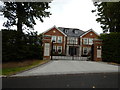
Oxshott - Recent Rebuilt House on Leys Road
This is one very large detached house or small mansion.
Image: © James Emmans
Taken: 7 Aug 2016
0.05 miles
2
Montrose Gardens
The end of Montrose Gardens, a cul-de-sac on the Oxshott Crown Estate. Or not quite the end: visible to the left of the gates into The Willows is a gap between the hedges, which is the rather overgrown eastern terminus of an alleyway linking Montrose Gardens to Broomfield Ride. Given the character of the estate, it's hardly surprising that the alleyway does not seem to be greatly used.
Image: © Hugh Craddock
Taken: 24 Jul 2013
0.06 miles
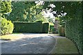
3
Broomfield Ride
Entrance to Broomfield Ride off Fair Oak Lane: this entrance is closed by electronically operated gates to prevent unauthorised through traffic.
Image: © Hugh Craddock
Taken: 24 Jul 2013
0.13 miles
5
Railway bridge over Heath Road
Looking north-west.
Image: © Andrew Longton
Taken: 8 Sep 2005
0.22 miles
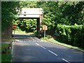
6
Heath Road railway bridge
Heath Road descends from Warren Lane parallel to the New Guildford line, before turning a right-angle to pass under the railway and out to Fairoak Lane. Heath Road is one-way beyond the bridge. The bridge has been recently replaced: compare with Image, which shows that the upper part of the abutments has been rebuilt.
Image: © Hugh Craddock
Taken: 10 Aug 2013
0.23 miles
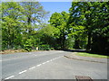
7
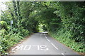
Heath Road
Heath Road, looking uphill towards the junction with Queen's Drive. The road is one-way, with a cycle track (also one-way) marked down the near side.
Image: © Hugh Craddock
Taken: 10 Aug 2013
0.23 miles
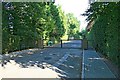
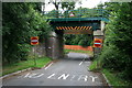
8
Heath Road
Junction of Heath Road and Image Queen's Drive is closed off with these gates, which are kept locked: access is via the other end, at the junction with Warren Lane. Unusually for a country lane, Heath Road is a one-way street (as far as the railway bridge).
Image: © Hugh Craddock
Taken: 10 Aug 2013
0.24 miles
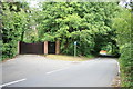
9
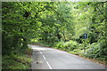
Heath Road
Heath Road is a one-way street providing a short-cut between Warren Lane and Fairoak Lane across Oxshott Heath. Before the railway was built, the road went straight ahead down to Fairoak Lane (then Steer Lane), where the bend to the left can now be seen to take the road under the railway line: Image At this time, Heath Road was no more than a sandy track across the heath. In the foreground, a horse ride crosses from Warren Lane to run along the edge of Oxshott Heath, and along an alleyway onto Queen's Drive.
Image: © Hugh Craddock
Taken: 9 Jul 2011
0.25 miles