IMAGES TAKEN NEAR TO
Elmwood Court, ASHTEAD, KT21 2RG
Introduction
This page details the photographs taken nearby to Elmwood Court, KT21 2RG by members of the Geograph project.
The Geograph project started in 2005 with the aim of publishing, organising and preserving representative images for every square kilometre of Great Britain, Ireland and the Isle of Man.

There are currently over 7.5m images from over14,400 individuals and you can help contribute to the project by visiting https://www.geograph.org.uk
Image Map
Images are licensed for reuse under creativecommons.org/licenses/by-sa/2.0
Notes
- Clicking on the map will re-center to the selected point.
- The higher the marker number, the further away the image location is from the centre of the postcode.
Image Listing (62 Images Found)
Images are licensed for reuse under creativecommons.org/licenses/by-sa/2.0
Image
Details
Distance
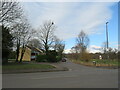
1
Balquhain Close, Ashtead
Balquhain Close is a short residential cul-de-sac in the village of Ashtead in Surrey.
This image was taken in the month of February. Trees were bare for the winter season.
Image: © Malc McDonald
Taken: 25 Feb 2023
0.05 miles
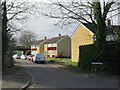
2
Woodfield, Ashtead
Woodfield is a resdiential road in the village of Ashtead in Surrey. Houses on the left side of the road look out across Wood Field, part of Ashtead Common, on the right.
This image was taken in the month of February. Trees were bare for the winter season.
Image: © Malc McDonald
Taken: 25 Feb 2023
0.06 miles
3
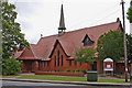
St. George's Church & Christian Centre (1), Barnett Wood Lane
This Anglican church is in the same complex as St. George's Christian Centre, the Parish Office and the Youth Office. St George's Church works together with the other Anglican church in Ashtead, which is St. Giles.
Image
Image
Image: © P L Chadwick
Taken: 14 Aug 2010
0.07 miles
4
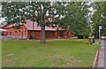
St. George's Church & Christian Centre (2), Barnett Wood Lane
The Christian Centre is at the end of the building nearest the camera, and the church is at the other end.
Image
Image
Image: © P L Chadwick
Taken: 14 Aug 2010
0.07 miles
5
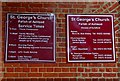
St. George's Church & Christian Centre (signs outside), Barnett Wood Lane
Image: © P L Chadwick
Taken: 14 Aug 2010
0.07 miles
6
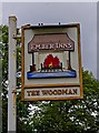
The Woodman (pub sign), 238 Barnett Wood Lane
The pub's sign is on a post outside, by the edge of the road. The pub itself is set well back from the road, and as a result it is in the adjoining OS grid square.
Image
Image: © P L Chadwick
Taken: 14 Aug 2010
0.07 miles
7
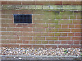
CBM - St. George's Church, Ashtead
Close-up of the OS cut-mark on the western end of St. George's church in (Lower) Ashtead, Surrey.
Waypoint: B13107 on the Bench-Marks website: https://www.bench-marks.org.uk/bm39887
Image: © Peter Vince
Taken: 13 May 2020
0.07 miles
8
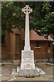
Lower Ashtead Memorial Cross
War memorial dating from 1920, situated by St George's Christian Centre by the junction of Oakfield Road and Barnett Wood Lane. For wider view see Image
Image: © Ian Capper
Taken: 20 Jul 2018
0.07 miles
9
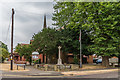
Lower Ashtead Memorial Cross
War memorial dating from 1920, situated by St George's Christian Centre by the junction of Oakfield Road and Barnett Wood Lane. For close up see Image
Image: © Ian Capper
Taken: 20 Jul 2018
0.07 miles
10
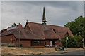
St George's Christian Centre
Originally a "tin tabernacle" mission church erected in 1882 to serve the growing community building up in Lower Ashtead. The current building dates from 1906, although it has been extended and enhanced over the years, culminating in a major redevelopment completed in 2001.
Image: © Ian Capper
Taken: 20 Jul 2018
0.07 miles