IMAGES TAKEN NEAR TO
Ashtead Woods Road, ASHTEAD, KT21 2EN
Introduction
This page details the photographs taken nearby to Ashtead Woods Road, KT21 2EN by members of the Geograph project.
The Geograph project started in 2005 with the aim of publishing, organising and preserving representative images for every square kilometre of Great Britain, Ireland and the Isle of Man.

There are currently over 7.5m images from over14,400 individuals and you can help contribute to the project by visiting https://www.geograph.org.uk
Image Map
Images are licensed for reuse under creativecommons.org/licenses/by-sa/2.0
Notes
- Clicking on the map will re-center to the selected point.
- The higher the marker number, the further away the image location is from the centre of the postcode.
Image Listing (17 Images Found)
Images are licensed for reuse under creativecommons.org/licenses/by-sa/2.0
Image
Details
Distance
1
Concessionary ride - Ashtead Common
Ashtead Common, which is a National Nature Reserve, is managed by the Corporation of the City of London. The rides are maintained by mowing 'scallops' at the edges on a cyclical basis.
Image: © Roger Miller
Taken: 11 Sep 2005
0.08 miles
2
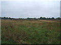
Woodfield - Ashtead Common
Woodfield is now being managed as a hay meadow. Grass and flowers are removed after mowing. This removes nutrients and helps increase wildflower diversity.
Image: © Roger Miller
Taken: 11 Sep 2005
0.08 miles
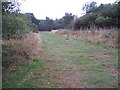
5
Shaun's Puddle
A small pond created in 2016 to aid with drainage of a very muddy area.
Image: © David Martin
Taken: 8 Apr 2022
0.13 miles
6
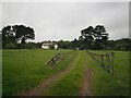
Around Ashtead Woods Road
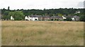
Pasture land, now occupied primarily by horses, surrounds one of a number of large houses that were built along Ashtead Woods Road in the late C19th/early C20th. The bank of trees beyond reveals the edge of Ashtead Common. Considering the location - on the northern edge of Ashtead, less than half a mile from the M25 and the border with Greater London - the scene is remarkably rural in character.
Image: © Thomas Grant
Taken: 9 May 2007
0.14 miles
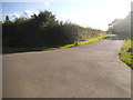
7
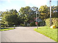
Ashtead Woods Road
This is a private road leading to the depths of Ashtead Common
Image: © David Howard
Taken: 31 Aug 2014
0.14 miles
8
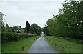
Ashtead Woods Road
Private road near Ashtead Common. Low density mixture of large houses, bungalows and grazing.
Image: © Thomas Grant
Taken: 9 May 2007
0.15 miles
9
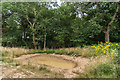
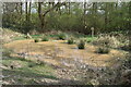
Pond
A part dried up pond on Ashtead Common.
Image: © Ian Capper
Taken: 20 Jul 2018
0.16 miles