IMAGES TAKEN NEAR TO
Lucas Park Drive, TADWORTH, KT20 7AE
Introduction
This page details the photographs taken nearby to Lucas Park Drive, KT20 7AE by members of the Geograph project.
The Geograph project started in 2005 with the aim of publishing, organising and preserving representative images for every square kilometre of Great Britain, Ireland and the Isle of Man.

There are currently over 7.5m images from over14,400 individuals and you can help contribute to the project by visiting https://www.geograph.org.uk
Image Map
Images are licensed for reuse under creativecommons.org/licenses/by-sa/2.0
Notes
- Clicking on the map will re-center to the selected point.
- The higher the marker number, the further away the image location is from the centre of the postcode.
Image Listing (34 Images Found)
Images are licensed for reuse under creativecommons.org/licenses/by-sa/2.0
Image
Details
Distance
1
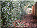
Footpath to Motts Hill Lane
A footpath between a holly hedge on one side and a garden fence on the other.
Image: © Stephen Craven
Taken: 31 Jan 2010
0.02 miles
2
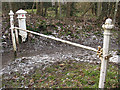
Coal Tax post no. 136
The white post is a coal tax post http://en.wikipedia.org/wiki/Coal_tax_post at a point where several rights of way converge. Although it appears not to coincide with any present day civil administrative boundary, it does lie on the boundary between the Anglican dioceses of Southwark (in which Tadworth lies) and Guildford (which includes Walton-on-the-Hill).
Image: © Stephen Craven
Taken: 31 Jan 2010
0.04 miles
3
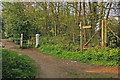
Footpath junction near Motts Hill Lane
The near two paths both lead to Motts Hill Lane, with the one leading away to the left being towards Withybed Corner. Note the Coal Tax Post - for close up see Image
Image: © Ian Capper
Taken: 24 Apr 2010
0.05 miles
4
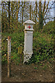
Coal Tax post no 136
This Coal Tax Post (no 136 on the list linked to below) is near the junction of footpaths from Motts Hill Lane to Withybed Corner - for context see Image
Image: © Ian Capper
Taken: 24 Apr 2010
0.05 miles
5
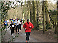
Running the Perch (2)
For the background to the race title see Image
Image: © Stephen Craven
Taken: 31 Jan 2010
0.08 miles
6
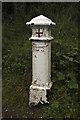
Coal Post
More than 200 of these "coal posts" were erected around London in 1861. The cost of rebuilding after the Great Fire was so enormous that a levy was imposed on coal brought into the City from 1834 until it was discontinued in 1890.
Image: © Kurseong Carl
Taken: 16 Jun 2012
0.08 miles
7
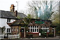
The Bell, Withybed Corner
A welcome sight, tucked away in the woods. On this occasion, I arrived before opening time, but my records show that I first visited on 1st May 1977.
Image: © Peter Trimming
Taken: 9 Dec 2014
0.10 miles
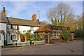
8
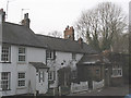
The Bell PH
The Bell is one of those out-of-the-way pubs - in this case it lies at the end of an unlit track into the woods - that could easily be missed altogether. According to one local we spoke to, the licensing laws are not too strictly observed.
Image: © Stephen Craven
Taken: 31 Jan 2010
0.11 miles
9
The Bell
This isolated pub, situated at the end of a dirt track (although signposted from the main road - see Image), was once a beer house - it can be seen that the pub has simply grown out of an ordinary cottage. It is apparently known as The Rat to the locals.
Image: © Ian Capper
Taken: 24 Apr 2010
0.11 miles
10
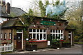
The Bell, Withybed Corner
A welcome sight, tucked away in the woods. On this occasion, I arrived before opening time, but my records show that I first visited on 1st May 1977.
Image: © Peter Trimming
Taken: 9 Dec 2014
0.11 miles