IMAGES TAKEN NEAR TO
Somerset Close, EPSOM, KT19 9JJ
Introduction
This page details the photographs taken nearby to Somerset Close, KT19 9JJ by members of the Geograph project.
The Geograph project started in 2005 with the aim of publishing, organising and preserving representative images for every square kilometre of Great Britain, Ireland and the Isle of Man.

There are currently over 7.5m images from over14,400 individuals and you can help contribute to the project by visiting https://www.geograph.org.uk
Image Map
Images are licensed for reuse under creativecommons.org/licenses/by-sa/2.0
Notes
- Clicking on the map will re-center to the selected point.
- The higher the marker number, the further away the image location is from the centre of the postcode.
Image Listing (21 Images Found)
Images are licensed for reuse under creativecommons.org/licenses/by-sa/2.0
Image
Details
Distance
1
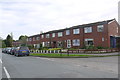
Hollymoor Lane
These modern red brick terraced houses are on Hollymoor Lane next to the junction with Somerset Close Which can just be seen going off on the right on the right hand edge of the image.
Image: © Nigel Mykura
Taken: 17 Apr 2015
0.04 miles
2
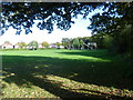
Chessington Road Recreation Ground
Chessington Road Recreation Ground (or Bakers Field) was purchased on 16th October 1930 by Epsom & Ewell Borough Council for £1,000. This view looks towards Chessington Road in the distance.
Image: © Marathon
Taken: 23 Oct 2013
0.10 miles
3
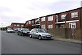
Sefton Rd
These unusual modern terraced houses with balconies at the front are on Sefton Rd next to the junction with Rutland Rd which can be seen going off to the right on the left of the picture. There is a small courtyard behind the houses for parking cars.
Image: © Nigel Mykura
Taken: 17 Apr 2015
0.12 miles
4
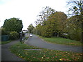
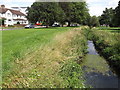
Green Lanes (west), Ewell
There is another road called Green Lanes on the other side of the tree lined stream (out of frame to the right).
Image: © Richard Vince
Taken: 29 Oct 2022
0.14 miles
5
Green Lanes, Ewell
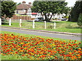
Suburban Ewell with flower beds, Mock Tudor houses and long green strips bordering the Hogsmill River.
www.epsomandewellhistoryexplorer.org.uk
Image: © Colin Smith
Taken: 17 Jul 2012
0.15 miles
6
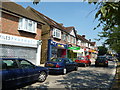
Ewell: Shops near Ewell West station
Image: © Dr Neil Clifton
Taken: 21 Jul 2013
0.15 miles
7
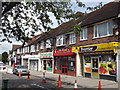
Ewell West Shops
Shopping parade, with flats above, facing on to the Chessington Road and close to Ewell West railway station.
www.epsomandewellhistoryexplorer.org.uk
Image: © Colin Smith
Taken: 17 Jul 2012
0.17 miles
8
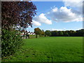
Chessington Road Recreation Ground
Chessington Road Recreation Ground (or Bakers Field) was purchased on 16th October 1930 by Epsom & Ewell Borough Council for £1,000. This view looks along the boundary with Chessington Road which is on the left.
Image: © Marathon
Taken: 23 Oct 2013
0.17 miles
9
Green Lanes, Hogsmill River
An area of grassy banks and Mock Tudor housing bordering a stretch of the Hogsmill River in suburban Ewell.
www.epsomandewellhistoryexplorer.org.uk
Image: © Colin Smith
Taken: 17 Jul 2012
0.17 miles
10
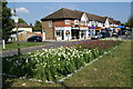
Flowerbed by a row of shops on Chessington Road
Image: © Bill Boaden
Taken: 1 Aug 2011
0.18 miles