IMAGES TAKEN NEAR TO
Headley Common Road, EPSOM, KT18 6NE
Introduction
This page details the photographs taken nearby to Headley Common Road, KT18 6NE by members of the Geograph project.
The Geograph project started in 2005 with the aim of publishing, organising and preserving representative images for every square kilometre of Great Britain, Ireland and the Isle of Man.

There are currently over 7.5m images from over14,400 individuals and you can help contribute to the project by visiting https://www.geograph.org.uk
Image Map
Images are licensed for reuse under creativecommons.org/licenses/by-sa/2.0
Notes
- Clicking on the map will re-center to the selected point.
- The higher the marker number, the further away the image location is from the centre of the postcode.
Image Listing (35 Images Found)
Images are licensed for reuse under creativecommons.org/licenses/by-sa/2.0
Image
Details
Distance
1
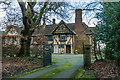
Great Hayes
A large house on the outskirts of Headley. Despite appearances, it wasn't built until the c1930s, first appearing on the 1933-4 1:10,560 map.
Image: © Ian Capper
Taken: 10 Jan 2020
0.01 miles
2
Great Hayes
A large house on the outskirts of Headley. Despite appearances, it wasn't built until the c1930s, first appearing on the 1933-4 1:10,560 map.
Image: © Ian Capper
Taken: 10 Jan 2020
0.01 miles
3
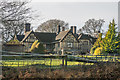
Great Hayes, Headley
This vast early C20 house on the edge of Headley Heath appears to comprise two separate dwellings.
Image: © Hugh Craddock
Taken: 21 Dec 2008
0.01 miles
4
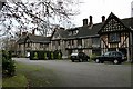
White Lodge, Headley Heath
White Lodge is one of several dwellings on the east side of Headley Heath accessible via driveways over the heath itself. The driveways are remarkably well maintained.
Image: © Hugh Craddock
Taken: 21 Dec 2008
0.11 miles
5
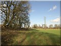
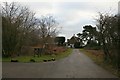
Approaching Heath Farm
Following footpath FP499 as a line of trees along a field boundary coverges with a pylon line.
Image: © Derek Harper
Taken: 3 Feb 2011
0.11 miles
6

Tye Lane
Bridleway BW494 connecting Headley Common Road and Dorking Road. The fact that it is named (and was so on 19th Century maps, so presumably historically) suggests that it is a very old route.
Image: © Ian Capper
Taken: 10 Jan 2020
0.12 miles
8
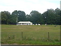
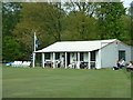
Stopping for Tea at Headley Cricket Club
This is on the route of 2012 Olympic Cycle Road Race and the London Green Belt Way.
Image: © Sean Davis
Taken: 5 Sep 2010
0.13 miles
9
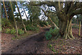
Tye Lane
Bridleway BW494 connecting Headley Common Road and Dorking Road. The fact that it is named (and was so on 19th Century maps, so presumably historically) suggests that it is a very old route.
Image: © Ian Capper
Taken: 10 Jan 2020
0.15 miles
10
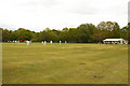
Headley Cricket Club
Founded in 1893, playing alongside Headley Common Road, opposite Headley Heath.
Image: © Ian Capper
Taken: 15 May 2010
0.15 miles