IMAGES TAKEN NEAR TO
Headley Road, EPSOM, KT18 6DH
Introduction
This page details the photographs taken nearby to Headley Road, KT18 6DH by members of the Geograph project.
The Geograph project started in 2005 with the aim of publishing, organising and preserving representative images for every square kilometre of Great Britain, Ireland and the Isle of Man.

There are currently over 7.5m images from over14,400 individuals and you can help contribute to the project by visiting https://www.geograph.org.uk
Image Map
Images are licensed for reuse under creativecommons.org/licenses/by-sa/2.0
Notes
- Clicking on the map will re-center to the selected point.
- The higher the marker number, the further away the image location is from the centre of the postcode.
Image Listing (19 Images Found)
Images are licensed for reuse under creativecommons.org/licenses/by-sa/2.0
Image
Details
Distance
1
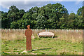
Jutland Wood
A seat and figure in Jutland Wood, an area in Langley Vale Wood, the largest of four First World War centenary woods developed by the Woodland Trust. The seat is by Andrew Lapthorn and the figure is by Christine Charlesworth.
Jutland Wood commemorates the Battle of Jutland in 1916, and the figure has two sides - the far side looking towards the original woodland in the background, which would have been in existence at the time of the battle, depicts a sailor in 1916 uniform, while the side seen here, looking towards the future woodland and depicts a sailor in 2016 uniform.
Image: © Ian Capper
Taken: 24 Aug 2021
0.09 miles
2
Jutland Wood
A seat and figure in Jutland Wood, an area in Langley Vale Wood, the largest of four First World War centenary woods developed by the Woodland Trust. The seat is by Andrew Lapthorn and the figure is by Christine Charlesworth.
Jutland Wood commemorates the Battle of Jutland in 1916, and the figure has two sides - the far side looking towards the original woodland in the background, which would have been in existence at the time of the battle, depicts a sailor in 1916 uniform, while the side seen here, looking towards the future woodland and depicts a sailor in 2016 uniform.
Image: © Ian Capper
Taken: 24 Aug 2021
0.09 miles
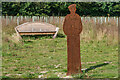
3
Jutland Wood
Area in Langley Vale Wood, the largest of four First World War centenary woods developed by the Woodland Trust. Each of the 14 boards created by Andrew Lapthorn commemorates a ship lost in the Battle of Jutland in 1916, listing the numbers from each drowned or surviving.
Image: © Ian Capper
Taken: 24 Aug 2021
0.09 miles
4
Jutland Wood
Area in Langley Vale Wood, the largest of four First World War centenary woods developed by the Woodland Trust. Each of the 14 boards created by Andrew Lapthorn commemorates a ship lost in the Battle of Jutland in 2016, listing the numbers from each drowned or surviving.
Image: © Ian Capper
Taken: 24 Aug 2021
0.09 miles
6
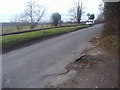
Walton Road looking towards Headley Road
Image: © David Howard
Taken: 20 Feb 2012
0.12 miles
7
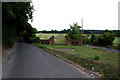
Headley: Entrance to Loretta Lodge
In the fork between Walton Road (left) and Headley Road. It looks as though this entrance is new, as there is no driveway here, possibly this will be constructed soon.
Image: © Dr Neil Clifton
Taken: 12 Aug 2013
0.13 miles
8
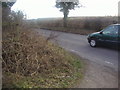
Headley: An awkward road junction
Headley Road is the main road, coming up from the left. The minor Walton Road slides in from the right.
Image: © Dr Neil Clifton
Taken: 12 Aug 2013
0.13 miles
9
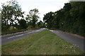
Entrance to Loretta Lodge
This is between Headley Road and Walton Road which is on the left. No sign of a lodge is in view.
Image: © David Howard
Taken: 20 Feb 2012
0.14 miles
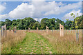
10

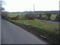
Langley Vale Wood
A section of Langley Vale Wood, the largest of four First World War centenary woods developed by the Woodland Trust, with distant views of Tolworth Tower, Wembley Stadium and One West Point in Acton.
Image: © Ian Capper
Taken: 24 Aug 2021
0.18 miles