IMAGES TAKEN NEAR TO
KT17 4RS
Introduction
This page details the photographs taken nearby to KT17 4RS by members of the Geograph project.
The Geograph project started in 2005 with the aim of publishing, organising and preserving representative images for every square kilometre of Great Britain, Ireland and the Isle of Man.

There are currently over 7.5m images from over14,400 individuals and you can help contribute to the project by visiting https://www.geograph.org.uk
Image Map
Images are licensed for reuse under creativecommons.org/licenses/by-sa/2.0
Notes
- Clicking on the map will re-center to the selected point.
- The higher the marker number, the further away the image location is from the centre of the postcode.
Image Listing (46 Images Found)
Images are licensed for reuse under creativecommons.org/licenses/by-sa/2.0
Image
Details
Distance
1
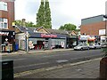
Epsom Town railway station (site), Surrey
Opened as "Epsom" in 1847 by the London Brighton and South Coast Railway on what is today the line from Croydon to Leatherhead, this station closed in 1929 when the current Epsom railway station was rebuilt to take the extra traffic. The 1847 station became "Epsom Town" from 1870 to c.1900, and again from 1923 until closure.
View north at the former forecourt. The building is still there, behind the modern shop frontages. And behind the building, the railway line still runs.
Image: © Nigel Thompson
Taken: 29 Sep 2020
0.02 miles
2
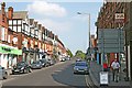
Upper High Street
Upper High Street from the junction with Church Street. Formerly known as Station Road, because the London, Brighton and South Coast Railway built a line to Epsom in 1847 which terminated at Epsom Town station, about half way up Station Road. The buildings are recognisable from this Francis Frith photo taken in 1902: http://www.francisfrith.com/epsom/photos/station-road-1902_48086/ and http://www.geograph.org.uk/stuff/frith.php?id=2361693 , although the closure of the station in 1929 has meant that, over the years, the focal point of the town has shifted west towards Epsom station and the Ashley Shopping Centre.
Image: © Hugh Craddock
Taken: 17 Apr 2011
0.03 miles
4
Late Victoriana, Epsom
No. 1 Church Street, Epsom - built for the Epsom and Ewell Technical Institute to the designs of architect John Hatchard-Smith (1853-1926).
"Building started on the Technical Institute in Church Street, Epsom in September 1893 on land given by Mr Basil Braithwaite of Hookfield. The architect was Mr John Hatchard-Smith and the builder and contractor was Mr J.B. Potter. The building was built in the English renaissance style and was completed in May 1896. The site was occupied until 1980 when it became inadequate for its purpose." - quoted from this http://www.epsomandewellhistoryexplorer.org.uk/TechnicalInstitute.html
Image: © Jim Osley
Taken: 27 Aug 2014
0.07 miles
5
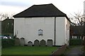
Bugby chapel and burial ground, Prospect Place
Side view of a former Calvinist chapel, built around 1780, by William Bugby, and later used as a Salem Baptist chapel and more recently as a synagogue. Now converted for office use. Grade II listed. To the east, in the foreground, is the burial ground, with a number of headstones laid against the east wall of the chapel. http://en.wikipedia.org/wiki/Bugby_Chapel
Image: © Hugh Craddock
Taken: 18 Feb 2014
0.08 miles
6
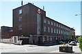
Royal Mail Offices, Epsom
Quite a good modernist brick building on East Street. The taller end block has a large vertical window.
Image: © Stephen Richards
Taken: Unknown
0.08 miles
8
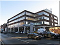
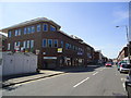
Page House, East Street, Epsom
A typical 1960's - 1970's office block with a car showroom on the ground floor.
Image: © Richard Rogerson
Taken: 17 Dec 2012
0.09 miles
9
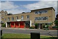
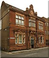
Epsom fire station
Epsom fire station, Church Street, Epsom, Surrey
Image: © Kevin Hale
Taken: 17 Jun 2007
0.09 miles
10
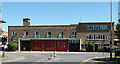
Fire Station, Epsom
On Church Street, by Pite, Son and Fairweather, 1937. A good, clean modern facade.
Image: © Stephen Richards
Taken: Unknown
0.09 miles