IMAGES TAKEN NEAR TO
Grove Road, EPSOM, KT17 4DE
Introduction
This page details the photographs taken nearby to Grove Road, KT17 4DE by members of the Geograph project.
The Geograph project started in 2005 with the aim of publishing, organising and preserving representative images for every square kilometre of Great Britain, Ireland and the Isle of Man.

There are currently over 7.5m images from over14,400 individuals and you can help contribute to the project by visiting https://www.geograph.org.uk
Image Map
Images are licensed for reuse under creativecommons.org/licenses/by-sa/2.0
Notes
- Clicking on the map will re-center to the selected point.
- The higher the marker number, the further away the image location is from the centre of the postcode.
Image Listing (105 Images Found)
Images are licensed for reuse under creativecommons.org/licenses/by-sa/2.0
Image
Details
Distance
1
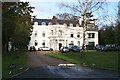
Grove House
Listed grade II house in The Grove, off Grove Road. Built around 1770, much of the gardens were developed in the nineteenth and early twentieth century, but a good diversity of trees has been retained. The walls around the estate can still be traced along nearby alleyways.
Image: © Hugh Craddock
Taken: 18 Feb 2014
0.04 miles
2

Grove Road green
A triangular open space on Grove Road, just north of Image Grove Road formerly ran around the outside of this triangle: the cut-off in the foreground was not constructed until between the two World Wars, when the Image estate was being developed with housing. The hedge confirms that the open space was formerly part of the field sandwiched between Grove Road and Grove Lane (Grove Lane is now Image), rather than an outlier of the churchyard.
Image: © Hugh Craddock
Taken: 18 Feb 2014
0.05 miles
3
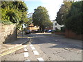
Church Street at the junction of Grove Road, Epsom
Image: © David Howard
Taken: 31 Aug 2014
0.06 miles
4
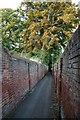
Grove Road to Church Road alleyway
This is one of several alleyways in this part of town which follow the alignment of old field paths, preserved as the town grew, first with villas surrounded by extensive walls, later redeveloped with higher density housing, but with the walls retained. The old walls give this alleyway (and that between the Railway Guard and Upper High Street) a flavour of an older Epsom. The alleyway is the course of Grove Lane, which in the nineteenth century was diverted into Grove Road. The wall on the left is the estate wall of Image
Image: © Hugh Craddock
Taken: 15 Jul 2008
0.06 miles
5

Grove Road to Church Road alleyway
This alley saves only 20m on a 160m walk along Grove Road and Church Road, but even after heavy snow, a well worn path has formed down the centre of the alleyway. For a further description and the view in summer, see Image
Image: © Hugh Craddock
Taken: 2 Feb 2009
0.06 miles
6

Grove Road
View (after abnormally heavy snow) down Grove Road towards Church Street, and (opposite the end of Grove Road) the offices of Bowles & Co, which occupies 18 Church Street, a late C17 building which was formerly the vicarage for Image
Image: © Hugh Craddock
Taken: 2 Feb 2009
0.06 miles
7
St Martin of Tours Epsom: mid February 2018
Also see http://www.bbc.co.uk/history/domesday/dblock/GB-520000-159000/page/17
Image: © Basher Eyre
Taken: 15 Feb 2018
0.07 miles
9
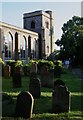
St Martin of Tours, nave and west tower
Image: © Hugh Craddock
Taken: 15 Jul 2008
0.07 miles
10
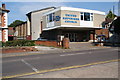
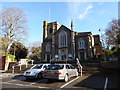
Epsom United Reformed Church
This is on Church Street, but the street was named after St Martin's rather than this.
Image: © Bill Boaden
Taken: 1 Aug 2011
0.08 miles