IMAGES TAKEN NEAR TO
Ewell Downs Road, EPSOM, KT17 3BN
Introduction
This page details the photographs taken nearby to Ewell Downs Road, KT17 3BN by members of the Geograph project.
The Geograph project started in 2005 with the aim of publishing, organising and preserving representative images for every square kilometre of Great Britain, Ireland and the Isle of Man.

There are currently over 7.5m images from over14,400 individuals and you can help contribute to the project by visiting https://www.geograph.org.uk
Image Map
Images are licensed for reuse under creativecommons.org/licenses/by-sa/2.0
Notes
- Clicking on the map will re-center to the selected point.
- The higher the marker number, the further away the image location is from the centre of the postcode.
Image Listing (11 Images Found)
Images are licensed for reuse under creativecommons.org/licenses/by-sa/2.0
Image
Details
Distance
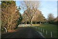
1
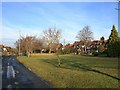
The Green
A private estate road on the east side of Epsom.
Image: © Hugh Craddock
Taken: 11 Jan 2009
0.07 miles
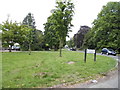
2
Cyclepath at The Green
Cyclepath/bridlepath 43 (from Albert Road in Epsom to the Cheam Road at Howell Hill) here crosses The Green, a private estate on the east side of Epsom.
Image: © Hugh Craddock
Taken: 11 Jan 2009
0.08 miles
3
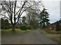
The Green
The Green, a private estate on the east side of Epsom, seen from the crossing of cyclepath/bridlepath 43. The Green is part of the Ewell Downs Road Conservation Area, developed from the late 1920s onwards by a local builder, Ernest Harwood, in a vernacular style. An 'article 4' direction means that local residents cannot make even the most minor changes to their homes (such as fitting new windows) without planning permission.
Image: © Hugh Craddock
Taken: 22 Feb 2009
0.10 miles
4
The Green at the junction of Longdown Lane North
Image: © David Howard
Taken: 1 Jun 2014
0.12 miles
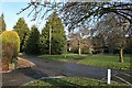
5
Gates between Higher Green and The Green
This pair of gates divide Higher Green from The Green: the latter is a private residential estate road, the former is a public road. Access can only be obtained to The Green off Longdown Lane North: the gates prevent through traffic except on foot or cycle.
Image: © Hugh Craddock
Taken: 11 Jan 2009
0.14 miles
6
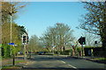
Pedestrian crossing on Reigate Road
As a bridleway goes left and right here, cycles and possibly horses may also use this crossing.
Image: © Robin Webster
Taken: 1 Apr 2012
0.16 miles
8
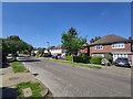
Windmill Close - Epsom
Detached houses near Wallace Fields Junior School.
Image: © James Emmans
Taken: 6 May 2020
0.21 miles
9
Houses by Higher Green (off Longdown Lane North)
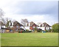
Quite substantial houses from the 'between-the-wars' period. While the three houses shown are basically very similar in plan, the builder has gone to some trouble to introduce a bit of variety - in the treatment of the little gabled wing that faces the street. In the house on the left this has timber framing with 'brick-nogging' as infill, while the middle house has tile-hanging - both inspired (if that's the word) by Surrey traditions.
The house on the right is more eccentric - the builder has contrived what might be called a gambrel roof, though a gambrel roof normally involves one change of slope rather than two. I think I'm reminded more of Essex Image than of Surrey.
The same houses appear in Hugh Craddock's Image He plainly knows the area far better than I do, and his contributions give more history.
Image: © Stefan Czapski
Taken: 18 Jan 2018
0.22 miles
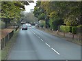
10
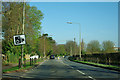
A240 - speed camera warning
The road here has a 30 limit, but looks much the same as when it had a 40 limit a bit further back, so it is easy to forget.
Image: © Robin Webster
Taken: 1 Apr 2012
0.23 miles