IMAGES TAKEN NEAR TO
Douglas Road, KINGSTON UPON THAMES, KT1 3PX
Introduction
This page details the photographs taken nearby to Douglas Road, KT1 3PX by members of the Geograph project.
The Geograph project started in 2005 with the aim of publishing, organising and preserving representative images for every square kilometre of Great Britain, Ireland and the Isle of Man.

There are currently over 7.5m images from over14,400 individuals and you can help contribute to the project by visiting https://www.geograph.org.uk
Image Map
Images are licensed for reuse under creativecommons.org/licenses/by-sa/2.0
Notes
- Clicking on the map will re-center to the selected point.
- The higher the marker number, the further away the image location is from the centre of the postcode.
Image Listing (60 Images Found)
Images are licensed for reuse under creativecommons.org/licenses/by-sa/2.0
Image
Details
Distance
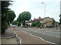
3
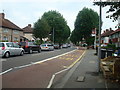
Speed Bumps, Douglas Rd
This view north up Douglas Road from close to its junction with King Henry Road shows a range of traffic calming measures and traffic controls such as speed bumps, cycle lanes, 20 mph speed restrictions and road narrowing devices.
Image: © Nigel Mykura
Taken: 30 Oct 2012
0.10 miles
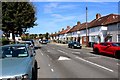
4
King Henry's Road, Kingston Upon Thames
Image: © Stacey Harris
Taken: 10 Sep 2010
0.14 miles
5
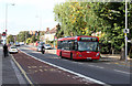
Kingston Road
An X26 bus service makes its way along the A2043, bound for Croydon from Heathrow Airport. The service is operated by Metrobus - a medium sized independent operator based in Crawley.
Image: © Martin Addison
Taken: 29 Oct 2011
0.14 miles
7
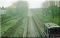
SE from Gloucester Road up the railway on a wintry Sunday, 1977
View towards New Malden and Waterloo: ex-LSWR Waterloo - Kingston etc. line. The line was in occupation by Engineers for renovation - see Image
Image: © Ben Brooksbank
Taken: 10 Mar 1977
0.15 miles
8
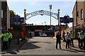
The entrance to Kingsmeadow on Cambridge Road
Kingsmeadow is now called the Cherry Red Records Stadium.
Image: © Steve Daniels
Taken: 29 Sep 2018
0.15 miles
9
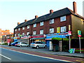
Row of Houses on Cambridge Rd the A2043
There are five shops on the ground floor of this apartment block with the upper two stories being residential. The shops are from the left, Cambridge Fish Bar, Milano Barbers ( existing in 2016, but when this photo was taken the property was unoccupied), then a SPAR convenience store and then Daal Handi an Idian Restaurant and lastly Fatboys Cafe and Restaurant. Although by July 2016 three years after this photo was taken Fat Boys Cafe and Restaurant had taken over Daal Handi and the Indian restaurant had disappeared.
Image: © Nigel Mykura
Taken: 21 Jul 2013
0.16 miles