IMAGES TAKEN NEAR TO
Citadel Place, AYR, KA7 1JN
Introduction
This page details the photographs taken nearby to Citadel Place, KA7 1JN by members of the Geograph project.
The Geograph project started in 2005 with the aim of publishing, organising and preserving representative images for every square kilometre of Great Britain, Ireland and the Isle of Man.

There are currently over 7.5m images from over14,400 individuals and you can help contribute to the project by visiting https://www.geograph.org.uk
Image Map
Images are licensed for reuse under creativecommons.org/licenses/by-sa/2.0
Notes
- Clicking on the map will re-center to the selected point.
- The higher the marker number, the further away the image location is from the centre of the postcode.
Image Listing (796 Images Found)
Images are licensed for reuse under creativecommons.org/licenses/by-sa/2.0
Image
Details
Distance
1
Riverbank Nursery
A long-established town centre nursery, located on the corner of Fort Street and Citadel Lane. The street names come from the Cromwellian fort which was built here in 1652-3.
Image: © Mary and Angus Hogg
Taken: 6 Mar 2009
0.00 miles
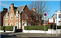
2
Citadel Place
From the junction with Montgomerie Terrace.
Image: © Billy McCrorie
Taken: 31 Mar 2012
0.02 miles
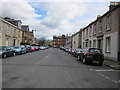
4
Fort Street, Ayr
Looking north, towards the harbour, on a fine March morning. The blue building in the foreground is the Dansarena studios. It was built in the early 19th century as the New Church, which became Cathcart Church after an amalgamation in 1951. The original gateway has been retained. (Source: "Ayrshire: Discovering A County", by Dane Love). The sandstone building to the north is Ayr Academy. Fort Street takes its name from the Cromwellian fort that was built on this site in 1652-3.
Image: © Mary and Angus Hogg
Taken: 6 Mar 2009
0.02 miles
5
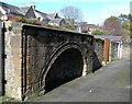
The Citadel Gate
This old gate in Citadel Lane was the main entrance to the fort which was built here by the Cromwellian government in 1652. The fort was abandoned in 1660 when Charles II was restored to the throne. The buildings were dismantled in the early 18th century but this gate and large sections of the walls still survive. (Source: information plaque in the gate). The original gate was much higher than this photo suggests, as the ground level here has risen in height.
Image: © Mary and Angus Hogg
Taken: 6 Mar 2009
0.02 miles
6
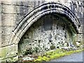
Ayr Citadel Gate
Under Oliver Cromwell five citadels were built in Scotland between 1650 and 1660 to control the Scots, such as at Leith, Perth, Inverlochy, Ayr and Inverness, with Ayr being the largest and most heavily defended.
This was the main gateway to Ayr Citadel Fort.
The fort was abandoned in 1660 when Charles II was restored to the throne. The fort was dismantled in the early 18th century, but this gate and large sections of the walls still survive.
The lower part of the gateway has been filled up to form Citadel Lane and the entrance itself has been built up.
Image: © Raibeart MacAoidh
Taken: 8 Mar 2018
0.02 miles
7
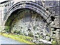
Ayr Citadel Gate
Under Oliver Cromwell five citadels were built in Scotland between 1650 and 1660 to control the Scots, such as at Leith, Perth, Inverlochy, Ayr and Inverness, with Ayr being the largest and most heavily defended.
This was the main gateway to Ayr Citadel Fort.
The fort was abandoned in 1660 when Charles II was restored to the throne. The fort was dismantled in the early 18th century, but this gate and large sections of the walls still survive.
The lower part of the gateway has been filled up to form Citadel Lane and the entrance itself has been built up.
Image: © Raibeart MacAoidh
Taken: 8 Mar 2018
0.02 miles
8
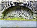
Ayr Citadel Gate
Under Oliver Cromwell five citadels were built in Scotland between 1650 and 1660 to control the Scots, such as at Leith, Perth, Inverlochy, Ayr and Inverness, with Ayr being the largest and most heavily defended.
This was the main gateway to Ayr Citadel Fort.
The fort was abandoned in 1660 when Charles II was restored to the throne. The fort was dismantled in the early 18th century, but this gate and large sections of the walls still survive.
The lower part of the gateway has been filled up to form Citadel Lane and the entrance itself has been built up.
Image: © Raibeart MacAoidh
Taken: 8 Mar 2018
0.02 miles
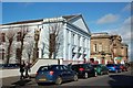
9
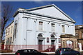
Former Cathcart Church, Fort Street, Ayr
Category B-listed. Built 1807-10. Architect David Hamilton. Alterations in 1900 by J & H V Eaglesham. Now premises of Dansarena Studios.
Image: © Leslie Barrie
Taken: 21 Mar 2015
0.03 miles
10
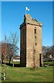
St John's Tower
This is all that remains of the parish church of St John. The building was requisitioned in 1652 by Oliver Cromwell, who was constructing a citadel in Ayr. The tower, which was restored to its original style in 1924, gave a useful lookout point for the fort. The flag is for the "Homecoming" event which celebrates the 250th anniversary of the birth of Robert Burns.
Image: © Mary and Angus Hogg
Taken: 25 Feb 2009
0.03 miles