IMAGES TAKEN NEAR TO
Ballochmyle View, MAUCHLINE, KA5 6EN
Introduction
This page details the photographs taken nearby to Ballochmyle View, KA5 6EN by members of the Geograph project.
The Geograph project started in 2005 with the aim of publishing, organising and preserving representative images for every square kilometre of Great Britain, Ireland and the Isle of Man.

There are currently over 7.5m images from over14,400 individuals and you can help contribute to the project by visiting https://www.geograph.org.uk
Image Map
Images are licensed for reuse under creativecommons.org/licenses/by-sa/2.0
Notes
- Clicking on the map will re-center to the selected point.
- The higher the marker number, the further away the image location is from the centre of the postcode.
Image Listing (67 Images Found)
Images are licensed for reuse under creativecommons.org/licenses/by-sa/2.0
Image
Details
Distance
1
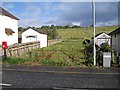
Access to the cattle
A gap between the houses in Mauchline Road, Catrine, provides a way onto the land on which cattle are grazing. However, the gateway has clearly not seen recent use, so there has to be a more convenient route into the pasture.
Image: © Richard Dorrell
Taken: 28 Sep 2012
0.02 miles
2
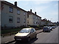
Mauchline Road
Council housing in Catrine
Image: © Angela Mudge
Taken: 19 Jul 2006
0.03 miles
3
Burn o' Need Way
Houses on the left of this cul-de-sac in Catrine back onto the Burn o' Need.
Image: © Richard Dorrell
Taken: 28 Sep 2012
0.06 miles
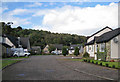
4
Burnpark, Catrine
A modern housing development in Catrine, viewed from a short alleyway which connects to Mauchline Road.
Image: © Richard Dorrell
Taken: 28 Sep 2012
0.10 miles
5
House in Catrine
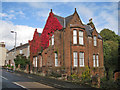
Located close to the corner of Mauchline Road and Ballochmyle Street, this red sandstone house is in danger of disappearing beneath a blanket of Virginia Creeper.
Image: © Richard Dorrell
Taken: 28 Sep 2012
0.10 miles
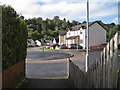
6

Corner of Ballochmyle Street & Mauchline Road, Catrine
Image: © Leslie Barrie
Taken: 26 Mar 2014
0.12 miles
7

Burn o' Need / Ayr confluence
The Burn o' Need meets the River Ayr downstream of Catrine.
Image: © Richard Webb
Taken: 22 Apr 2017
0.13 miles
8

River Ayr Way, Catrine
The gorge scenery starts again with crags below Ballochmyle.
Image: © Richard Webb
Taken: 22 Apr 2017
0.14 miles
9
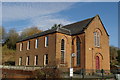
Former Congregational Church, Catrine
Built in 1845 as the Free Church, it later became the Congregational Church in 1960. Since closing for worship in 2002 it has now become a private dwelling.
Image: © Leslie Barrie
Taken: 5 Nov 2012
0.15 miles
10
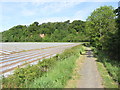
On River Ayr Way, W of Catrine - View northwest
Using the bus service from Mossblown to Catrine, this section of the River Ayr Way can be easily walked in a day and has a good firm surface the whole way.
Image: © Colin Park
Taken: 5 Jun 2012
0.15 miles