IMAGES TAKEN NEAR TO
Hill Street, MAUCHLINE, KA5 5QZ
Introduction
This page details the photographs taken nearby to Hill Street, KA5 5QZ by members of the Geograph project.
The Geograph project started in 2005 with the aim of publishing, organising and preserving representative images for every square kilometre of Great Britain, Ireland and the Isle of Man.

There are currently over 7.5m images from over14,400 individuals and you can help contribute to the project by visiting https://www.geograph.org.uk
Image Map
Images are licensed for reuse under creativecommons.org/licenses/by-sa/2.0
Notes
- Clicking on the map will re-center to the selected point.
- The higher the marker number, the further away the image location is from the centre of the postcode.
Image Listing (126 Images Found)
Images are licensed for reuse under creativecommons.org/licenses/by-sa/2.0
Image
Details
Distance
1
The motte and bailey, Tarbolton
Seen here from the housing estate (using zoom - I wasn't in the garden!)
Image: © Humphrey Bolton
Taken: 10 Oct 2017
0.03 miles
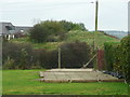
2
Motte, Tarbolton
Seen here from Hill Street.
Image: © Humphrey Bolton
Taken: 10 Oct 2017
0.03 miles
3
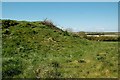
Tarbolton Motte From The Bailey
The 12th century Motte at Tarbolton was surrounded on 3 sides by a Bailey. In this view, the sloping edge of the Motte is seen from the flat platform that was the Bailey. The Motte was the site of a wooden house or tower, which would be the home of the local lord. The Bailey was a surrounding base court containing the necessary services, such as stables, kitchens and workshops. Tarbolton Bailey would have been protected by a timber fence, combined with the naturally steep slope on 3 sides. (Source: The Castles of South-West Scotland", by Mike Salter)
Image: © Mary and Angus Hogg
Taken: 12 May 2009
0.03 miles
4
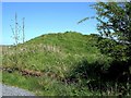
Tarbolton Motte
This is the first view of the 12th century Motte at Tarbolton, approached from the access road for new houses at the end of Garden Street. The B744 makes a sharp detour round the other side of the site.
Image: © Mary and Angus Hogg
Taken: 12 May 2009
0.03 miles
5
Tarbolton Bailey From The Motte
The Motte at Tarbolton was set at the rear left-hand side of the Bailey. In this view, the foreground shows the edge of the Motte, where the lord's home would have been sited. Beyond this is a flat area with a rounded outline, which was the Bailey. This would have been the location of essential services for the house or tower on the Motte. Beyond the Bailey, the ground slopes away steeply to the current B744, tucked away out of sight in this view.
Image: © Mary and Angus Hogg
Taken: 12 May 2009
0.04 miles
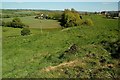
6
Bachelors' Club
In this house Robert Burns used to meet his friends.
Image: © Anne Burgess
Taken: Unknown
0.04 miles
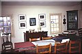
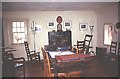
7
Bachelors' Club
Inside the Bachelors' Club
Image: © Anne Burgess
Taken: Unknown
0.04 miles
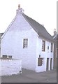
8
Bachelors' Club
Interior of the Bachelors' Club
Image: © Anne Burgess
Taken: Unknown
0.04 miles
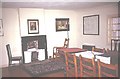
9
Bachelors' Club
A room in the Bachelors' Club
Image: © Anne Burgess
Taken: Unknown
0.04 miles
10

Garden Street, Tarbolton
Heading into Tarbolton from the NorthEast this is the first part of the small town you see, and it is fairly representative of it as a whole - a mix of buildings from various times, some grander than others, but all pleasant enough. There isn't really much of an outskirt to Tarbolton; it just starts and then stops, with definite edges. Once inside, it always feels like you are at the centre.
Obviously this is a bit of a generalisation, particularly as I am only an occasional visitor to the three Ayrshires (East, North and South), but to me the small towns always have a similar feel. They're nothing too special, but all quite pleasant, and have a feeling of self-sufficient contentment about them. Life seems to be being lived at the correct pace.
The row of bungalows on the right was already here by the time of Ordnance Survey's first map of here, surveyed in the 1850s. A couple of small square plots are shown on the street on that first map, filled in with matrices of round trees, where more modern houses now sit. So perhaps the street took its name from these, as small orchards can also be referred to as 'fruit gardens'.
Image: © Ian Dodds
Taken: 5 Aug 2024
0.05 miles