IMAGES TAKEN NEAR TO
Red Rose Way, MAUCHLINE, KA5 5PH
Introduction
This page details the photographs taken nearby to Red Rose Way, KA5 5PH by members of the Geograph project.
The Geograph project started in 2005 with the aim of publishing, organising and preserving representative images for every square kilometre of Great Britain, Ireland and the Isle of Man.

There are currently over 7.5m images from over14,400 individuals and you can help contribute to the project by visiting https://www.geograph.org.uk
Image Map
Images are licensed for reuse under creativecommons.org/licenses/by-sa/2.0
Notes
- Clicking on the map will re-center to the selected point.
- The higher the marker number, the further away the image location is from the centre of the postcode.
Image Listing (32 Images Found)
Images are licensed for reuse under creativecommons.org/licenses/by-sa/2.0
Image
Details
Distance
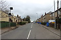
3
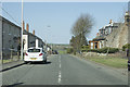
Leaving Tarbolton behind
This road has a mix of old stone built houses and some more modern ones that appear to have a grey render surface.
Image: © Malcolm Neal
Taken: 9 Apr 2019
0.17 miles
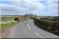
8
Tarbolton Motte
This is the first view of the 12th century Motte at Tarbolton, approached from the access road for new houses at the end of Garden Street. The B744 makes a sharp detour round the other side of the site.
Image: © Mary and Angus Hogg
Taken: 12 May 2009
0.20 miles
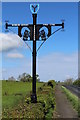
9
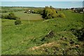
Tarbolton Bailey From The Motte
The Motte at Tarbolton was set at the rear left-hand side of the Bailey. In this view, the foreground shows the edge of the Motte, where the lord's home would have been sited. Beyond this is a flat area with a rounded outline, which was the Bailey. This would have been the location of essential services for the house or tower on the Motte. Beyond the Bailey, the ground slopes away steeply to the current B744, tucked away out of sight in this view.
Image: © Mary and Angus Hogg
Taken: 12 May 2009
0.20 miles
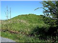
10
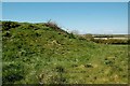
Tarbolton Motte From The Bailey
The 12th century Motte at Tarbolton was surrounded on 3 sides by a Bailey. In this view, the sloping edge of the Motte is seen from the flat platform that was the Bailey. The Motte was the site of a wooden house or tower, which would be the home of the local lord. The Bailey was a surrounding base court containing the necessary services, such as stables, kitchens and workshops. Tarbolton Bailey would have been protected by a timber fence, combined with the naturally steep slope on 3 sides. (Source: The Castles of South-West Scotland", by Mike Salter)
Image: © Mary and Angus Hogg
Taken: 12 May 2009
0.20 miles