IMAGES TAKEN NEAR TO
Western Road, KILMARNOCK, KA3 1LP
Introduction
This page details the photographs taken nearby to Western Road, KA3 1LP by members of the Geograph project.
The Geograph project started in 2005 with the aim of publishing, organising and preserving representative images for every square kilometre of Great Britain, Ireland and the Isle of Man.

There are currently over 7.5m images from over14,400 individuals and you can help contribute to the project by visiting https://www.geograph.org.uk
Image Map
Images are licensed for reuse under creativecommons.org/licenses/by-sa/2.0
Notes
- Clicking on the map will re-center to the selected point.
- The higher the marker number, the further away the image location is from the centre of the postcode.
Image Listing (38 Images Found)
Images are licensed for reuse under creativecommons.org/licenses/by-sa/2.0
Image
Details
Distance
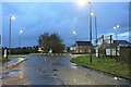
1
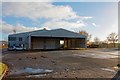
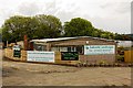
VOSA - Kilmarnock
Vehicle and Operator Services Agency for Passing Truck Class 1 and 2 licences and testing centre. This was where truck drivers would come to pass their licences but VOSA has now moved to Troon so it is no longer used for that purpose
Image: © Ian Rainey
Taken: 13 Nov 2018
0.02 miles
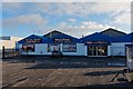
3
Advertising hoardings, Western Road
View of the less ugly side of advertising hoardings from a cycle path. Like all flat surfaces it has been fouled by spray painting morons. (I am not feeling too charitable towards graffiti rats right now, I have just been hit myself).
Image: © Richard Webb
Taken: 9 Sep 2009
0.05 miles
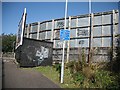
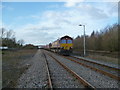
4
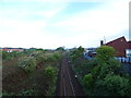
Railways, Kilmarnock
A bridge takes the B7064 over the trackbeds of two railways. The nearer line is still open and was the Glasgow and Kilmarnock Joint Railway running to Glasgow via
Stewarton. This was operated by the Caledonian Railway The further arch crosses the now closed Glasgow, Paisley, Kilmarnock and Ayr Railway a rival line operated by the Glasgow and South Western via Dalry. The Glasgow, Paisley, Kilmarnock and Ayr Railway track is still there in places, buried under vegetation. A 1976 map shows it as intact as far as Dalry. The line is now a cycle path, National Cycle Network route 73.
Image: © Richard Webb
Taken: 9 Sep 2009
0.05 miles
5
A roundabout on the B7064 towards West Hillhead
Traffic-free at daybreak on a Sunday.
Image: © Alan Reid
Taken: 6 Nov 2022
0.06 miles
6
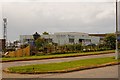
K. A. Tech Foam Centre - Kilmarnock
Upholstery and furniture repair centre
Image: © Ian Rainey
Taken: 9 May 2019
0.06 miles
7
Long Lyes Sidings
Siding used to Run Round south bound coal services so they can go back to either Greenburn or New Cumnock for loading
Image: © David Liddle
Taken: 11 Feb 2013
0.08 miles
8
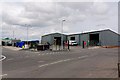
East Ayrshire Council Waste Management - Kilmarnock
Refuse and re-cycling centre
Image: © Ian Rainey
Taken: 9 May 2019
0.10 miles
9
Lakeside Landscapes - Kilmarnock
Landscape gardeners
Image: © Ian Rainey
Taken: 9 May 2019
0.12 miles
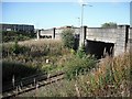
10
Kilmarnock to Glasgow railway
From the bridge on the B7064.
Image: © JThomas
Taken: 24 May 2021
0.13 miles