IMAGES TAKEN NEAR TO
Tarbolton Road, KILMARNOCK, KA2 9AS
Introduction
This page details the photographs taken nearby to Tarbolton Road, KA2 9AS by members of the Geograph project.
The Geograph project started in 2005 with the aim of publishing, organising and preserving representative images for every square kilometre of Great Britain, Ireland and the Isle of Man.

There are currently over 7.5m images from over14,400 individuals and you can help contribute to the project by visiting https://www.geograph.org.uk
Image Map
Images are licensed for reuse under creativecommons.org/licenses/by-sa/2.0
Notes
- Clicking on the map will re-center to the selected point.
- The higher the marker number, the further away the image location is from the centre of the postcode.
Image Listing (10 Images Found)
Images are licensed for reuse under creativecommons.org/licenses/by-sa/2.0
Image
Details
Distance
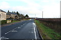
1
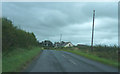
The B730
A minor road leaving Dundonald is still quite dull as the clouds are still low and threatening.
Image: © Malcolm Neal
Taken: 28 Aug 2019
0.05 miles
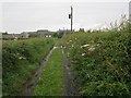
3
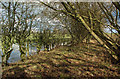
Old Farm Track Near Dundonald
It's just possible to make this out as an old track. The water on the left was only a flooded part of the field.
Image: © Mary and Angus Hogg
Taken: 1 Nov 2018
0.09 miles
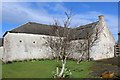
4
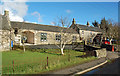
Farm Buildings At Laurieston
These buildings lie on the edge of Dundonald village, on the B730.
Image: © Mary and Angus Hogg
Taken: 1 Nov 2018
0.12 miles
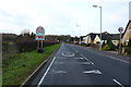
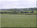
5
Laurieston
A farm road connecting two public roads.
Image: © Richard Webb
Taken: 18 Jul 2012
0.12 miles
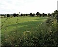
9
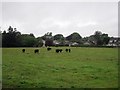
Aberdeen Angus cattle
A field on the edge of Dundonald; it was raining.
Image: © Richard Webb
Taken: 18 Jul 2012
0.21 miles
10
Lochside
The unusually named Lochside is in the middle of open pastures with no sign of a loch nearby
Image: © Ian Rainey
Taken: 1 Jun 2006
0.24 miles