IMAGES TAKEN NEAR TO
Whiting Bay, ISLE OF ARRAN, KA27 8QL
Introduction
This page details the photographs taken nearby to KA27 8QL by members of the Geograph project.
The Geograph project started in 2005 with the aim of publishing, organising and preserving representative images for every square kilometre of Great Britain, Ireland and the Isle of Man.

There are currently over 7.5m images from over14,400 individuals and you can help contribute to the project by visiting https://www.geograph.org.uk
Image Map
Images are licensed for reuse under creativecommons.org/licenses/by-sa/2.0
Notes
- Clicking on the map will re-center to the selected point.
- The higher the marker number, the further away the image location is from the centre of the postcode.
Image Listing (40 Images Found)
Images are licensed for reuse under creativecommons.org/licenses/by-sa/2.0
Image
Details
Distance
1
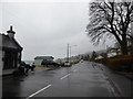
Looking southwards on the A841 at Whiting Bay
Image: © Basher Eyre
Taken: 3 Apr 2018
0.04 miles
2
Whiting Bay
This photograph of the A481 through the southern end of Whiting Bay was taken from near its junction with the road from South Kiscadale.
A few metres behind the viewpoint Image joins the A481.
On the left of the photograph it is just possible to see the Glenashdale Burn crossing the seashore.
To see a photograph (1968) taken from near the burn and looking back toward thus viewpoint, click here: http://www.geograph.org.uk/photo/1737103 .
Image: © Alan Walker
Taken: 27 Jun 2008
0.04 miles
4
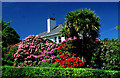
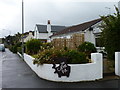
House with rhododendrons and NZ cabbage tree.
Whiting Bay, Arran.
Image: © Peter Ward
Taken: 29 May 2001
0.08 miles
5
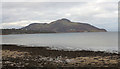
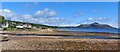
Beach at Whiting Bay
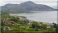
The beach at Whiting Bay, is a mixture of sand and rocks. Holy Island is seen distantly.
Image: © Trevor Littlewood
Taken: 20 Oct 2014
0.08 miles
6
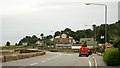
The road from South Kiscadale
This photograph of the A481 (ahead from the right) through Whiting Bay was taken from the garden of ‘The Coffee Pot’ at its junction with the road from South Kiscadale (from the left).
In the distance can be seen the Kingscross headland and beyond that Holy Island.
For a photograph of the seashore at Whiting Bay taken from the wall across the road, click here: http://www.geograph.org.uk/photo/1737103 .
For another photograph (1986) of the A481 about 0,5km north of this point, click here: http://www.geograph.org.uk/photo/1737058 .
- - -
See also this photograph by Gordon Brown: Image
Image: © Alan Walker
Taken: 27 Jun 2008
0.09 miles
7
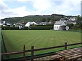
Whiting Bay Bowling Club
To the side of the Eden Lodge Hotel.
Image: © John M
Taken: 24 Jun 2012
0.09 miles
8
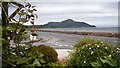
Arran - Whiting Bay - Beach north of Port Mòr
Looking along the beach to the north of Port Mòr in Whiting Bay, Arran with the bulk of Holy Island in the distance on the right.
Image: © Rob Farrow
Taken: 24 Aug 2024
0.10 miles
9
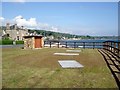
Grassy promontory with a small stone hut
This is an increasingly common view around the Clyde. The scene is actually of a sewage treatment scheme - all the old individual house sewers (discharging straight into the Clyde) are now caught in a shore-side pipe and taken to this common control and treatment point.
Image: © Gordon Brown
Taken: 13 May 2007
0.10 miles