IMAGES TAKEN NEAR TO
Lamlash, ISLE OF ARRAN, KA27 8LY
Introduction
This page details the photographs taken nearby to KA27 8LY by members of the Geograph project.
The Geograph project started in 2005 with the aim of publishing, organising and preserving representative images for every square kilometre of Great Britain, Ireland and the Isle of Man.

There are currently over 7.5m images from over14,400 individuals and you can help contribute to the project by visiting https://www.geograph.org.uk
Image Map
Images are licensed for reuse under creativecommons.org/licenses/by-sa/2.0
Notes
- Clicking on the map will re-center to the selected point.
- The higher the marker number, the further away the image location is from the centre of the postcode.
Image Listing (104 Images Found)
Images are licensed for reuse under creativecommons.org/licenses/by-sa/2.0
Image
Details
Distance
3
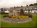
Lamlash: Arran Clearance memorial
Commemorating the interesting story of the colonisation by some of the islanders of provincial Canada, this monument has around the side a plaque which reads:
Erected on behalf of Arran clearance descendants across North America, to their brave forefathers who departed from their beloved island home to Canada during the clearance years 1829 to 1840. Here at Lamlash on April 25th 1829 part of the clearance (89 souls) when embarking on the brig Caledonia (196 tons), the Rev. A. Mackay preached from The Mound (opposite) formed by the departing, his text "Casting all your care upon him: for he careth for you." 1st Peter ch.5 v.7.
The Caledonia arrived at Quebec City June 25th 1829. The group was the first of more than 300 Arran colonists of Megantic County, Province of Quebec. The largest group, more than 400, had as their destination the seaport town of Dalhousie, New Brunswick, to be pioneer settlers of the Restigouche-Bay Chaleur District
"Yet still the blood is strong, the heart is highland"
A chlann eilean mo ghaoil bithibh dileas d'a cheile
The Mound referred to in the text can be seen here: Image
Image: © Chris Downer
Taken: 27 Sep 2010
0.02 miles
4
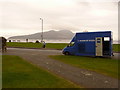
Lamlash: mobile Bank of Scotland
This is the third time today that I would encounter the mobile branch of the Bank of Scotland at one of its stops - see Image and Image
These being three of the more major villages on the island, it calls for an hour at each. On other days of the week its timetable includes shorter stops at some of the tinier places.
Image: © Chris Downer
Taken: 27 Sep 2010
0.03 miles
6
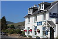
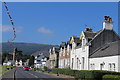
Main Street, Lamlash - the A841
Houses, hotels and guest houses - nearest are the Glen Isle hotel and the Lilybank Guest House.
Image: © M J Richardson
Taken: 8 May 2011
0.04 miles
7
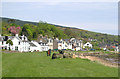
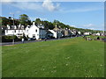
View from Hamilton Terrace
Looking out to Lamlash Bay, with Holy Island rising on the left.
Image: © John Allan
Taken: 31 Aug 2020
0.04 miles
8
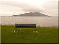
Lamlash: bench with island view
This bench provides a nice seaside view, over the bay towards Holy Island.
Image: © Chris Downer
Taken: 27 Sep 2010
0.04 miles
9
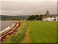
Lamlash: shoreline and parish church
A view along the shore at the village centre, with the parish church (in the next square south) in the background.
Image: © Chris Downer
Taken: 27 Sep 2010
0.05 miles
10
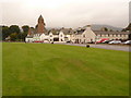
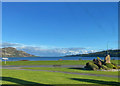
Lamlash: The Mound
This small, unassuming mound, in the lawn alongside the shore, was formed by the first of 400 islanders who resettled in Canada, leaving Lamlash for their new lives on 25 April 1829. The Rev. A. Mackay preached from it on that day as they set sail. For the whole story, see Image
The memorial is opposite, just across the road to our right.
The village centre, including shops and the parish church, is in the background.
Image: © Chris Downer
Taken: 27 Sep 2010
0.05 miles