IMAGES TAKEN NEAR TO
Pinwherry, GIRVAN, KA26 0SQ
Introduction
This page details the photographs taken nearby to KA26 0SQ by members of the Geograph project.
The Geograph project started in 2005 with the aim of publishing, organising and preserving representative images for every square kilometre of Great Britain, Ireland and the Isle of Man.

There are currently over 7.5m images from over14,400 individuals and you can help contribute to the project by visiting https://www.geograph.org.uk
Image Map
Images are licensed for reuse under creativecommons.org/licenses/by-sa/2.0
Notes
- Clicking on the map will re-center to the selected point.
- The higher the marker number, the further away the image location is from the centre of the postcode.
Image Listing (3 Images Found)
Images are licensed for reuse under creativecommons.org/licenses/by-sa/2.0
Image
Details
Distance
1
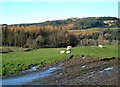
A Glaury Field Entrance
The entrance to this field near Colmonell has become completely choked with thick, soft mud (or glaur, as we say in Scotland) after a long period of wet weather.
Image: © Mary and Angus Hogg
Taken: 11 Nov 2009
0.15 miles
2
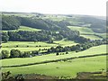
View of the Stinchar Valley
Looking from the side of Prieston Hill across the river towards Dalreoch wood.
The road between Pinwherry and Colmonell running parallel to the river.
Image: © Harriet Ellis
Taken: 15 Sep 2010
0.18 miles
3
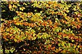
Autumn Colours In Dalreoch Wood
Viewed in mid-November. The lower branches of the Beech trees still held their leaves in a glory of autumn colour. The upper branches were stripped bare by the wind.
Image: © Mary and Angus Hogg
Taken: 11 Nov 2009
0.22 miles