IMAGES TAKEN NEAR TO
MAYBOLE, KA19 7PD
Introduction
This page details the photographs taken nearby to KA19 7PD by members of the Geograph project.
The Geograph project started in 2005 with the aim of publishing, organising and preserving representative images for every square kilometre of Great Britain, Ireland and the Isle of Man.

There are currently over 7.5m images from over14,400 individuals and you can help contribute to the project by visiting https://www.geograph.org.uk
Image Map
Images are licensed for reuse under creativecommons.org/licenses/by-sa/2.0
Notes
- Clicking on the map will re-center to the selected point.
- The higher the marker number, the further away the image location is from the centre of the postcode.
Image Listing (17 Images Found)
Images are licensed for reuse under creativecommons.org/licenses/by-sa/2.0
Image
Details
Distance
3
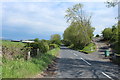
Old Milestone by the B7023, south west of Maybole
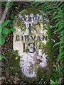
Milestone by the B7023, in parish of Maybole (Carrick District), Lachlands, under tree, behind ditch on long straight hill.
Inscription reads:-
MAYBOLE
1
GIRVAN
13
Cut bench mark on lower face.
Surveyed
Milestone Society National ID: AYS_MBGVS01
Image: © Milestone Society
Taken: Unknown
0.08 miles
5
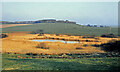
Heart Loch view 1975
This 1975 view shows the heart-shaped outline of this little loch near Maybole which was left by the receding ice towards the end of the last glaciation. Fire damage to the reed bed in 2001 removed the heart shape Image
Image: © Mary and Angus Hogg
Taken: Unknown
0.09 miles
6
The Heart Loch
The loch took its name from its original heart-shaped outline, but it looks different nowadays. Image explains what happened to the heart-shaped outline in 2001.
Image: © Mary and Angus Hogg
Taken: 22 Nov 2007
0.09 miles
7
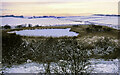
How the Heart Loch got its name
This 1979 snow scene shows how the Heart Loch got its name. A small floating island of reeds was able to move across the surface but usually was in the position shown here, creating the heart shape. Image also shows the outline.
Image: © Mary and Angus Hogg
Taken: Unknown
0.09 miles
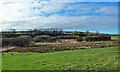
8
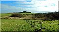
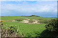
Heart Loch view
Viewed from outside the square on a bright late-February morning. The open water isn't visible from this angle. For information on the background of the Heart Loch, see Image
Image: © Mary and Angus Hogg
Taken: 26 Feb 2021
0.09 miles
9
Heart Loch again
An unusual view of the Heart Loch overlooked by Lochbrae Cottage.
Image: © Mary and Angus Hogg
Taken: 26 Feb 2021
0.09 miles
10
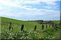
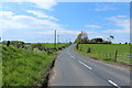
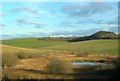
Farmland near Lochbrae
With view to Maybole.
Image: © Billy McCrorie
Taken: 30 May 2013
0.09 miles