IMAGES TAKEN NEAR TO
Ladyland Road, MAYBOLE, KA19 7DH
Introduction
This page details the photographs taken nearby to Ladyland Road, KA19 7DH by members of the Geograph project.
The Geograph project started in 2005 with the aim of publishing, organising and preserving representative images for every square kilometre of Great Britain, Ireland and the Isle of Man.

There are currently over 7.5m images from over14,400 individuals and you can help contribute to the project by visiting https://www.geograph.org.uk
Image Map
Images are licensed for reuse under creativecommons.org/licenses/by-sa/2.0
Notes
- Clicking on the map will re-center to the selected point.
- The higher the marker number, the further away the image location is from the centre of the postcode.
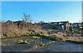
Image Listing (398 Images Found)
Images are licensed for reuse under creativecommons.org/licenses/by-sa/2.0
Image
Details
Distance
1
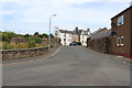
Lady Walk, Maybole
The higher-level part of the new housing area is called Lady Walk. See Image for previous views and information.
Image: © Mary and Angus Hogg
Taken: 24 Jul 2021
0.01 miles
5
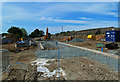
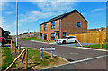
Building work progresses at Ladyland Road
After the lockdown stoppage, work has restarted on the house building site at Maybole's Ladyland Road. The image from the end of March Image shows how much has been done since the start of July 2020. The August view shows the rear part of the site which looked like Image before the work started.
Image: © Mary and Angus Hogg
Taken: 9 Aug 2020
0.03 miles
6
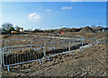
Ladyland Road building site
Work has started on a housing development in Ladyland Road. For previous views and information, see Image and Image
Image: © Mary and Angus Hogg
Taken: 22 Mar 2020
0.03 miles
7
Development work at Maybole's Ladyland Road
After the lockdown stoppage, work has restarted on the site at Maybole's Ladyland Road where new houses will replace the ruins of the former Community Centre - see Image for a 2014 view of this scene.
Image: © Mary and Angus Hogg
Taken: 9 Aug 2020
0.03 miles
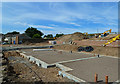
8

Ladyland Road housing development resumes
After the lockdown stoppage, work has restarted on the house building site at Maybole's Ladyland Road. There will be 4 houses along the roadside with more on the higher part of the site to the rear.
Image: © Mary and Angus Hogg
Taken: 9 Aug 2020
0.03 miles
9
Site of Maybole's former community centre
The building on this site was constructed as a Poorshouse, accommodating 48 destitute persons in the late 19th century. After the 1st World War, it was used for local government offices and the Labour Exchange. Further changes led to the use of the ground floor as a Welfare Centre, where the baby clinics were held. A small private playgroup used the upstairs rooms. The building was demolished when it became unsafe. Outline planning consent has been granted for the development of a supermarket but, in early 2020, a housing complex was started. There are no Geographs of the old building.
Image: © Mary and Angus Hogg
Taken: 2 Dec 2014
0.03 miles