IMAGES TAKEN NEAR TO
Glen Avenue, CUMNOCK, KA18 3HF
Introduction
This page details the photographs taken nearby to Glen Avenue, KA18 3HF by members of the Geograph project.
The Geograph project started in 2005 with the aim of publishing, organising and preserving representative images for every square kilometre of Great Britain, Ireland and the Isle of Man.

There are currently over 7.5m images from over14,400 individuals and you can help contribute to the project by visiting https://www.geograph.org.uk
Image Map
Images are licensed for reuse under creativecommons.org/licenses/by-sa/2.0
Notes
- Clicking on the map will re-center to the selected point.
- The higher the marker number, the further away the image location is from the centre of the postcode.
Image Listing (17 Images Found)
Images are licensed for reuse under creativecommons.org/licenses/by-sa/2.0
Image
Details
Distance
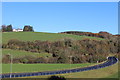
3
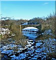
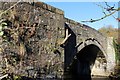
Logan Bridge
This stone bridge carried traffic between Logan and Lugar before the road was realigned. Viewed from the new bridge across the Lugar Water on a lovely crisp winter afternoon.
Image: © Mary and Angus Hogg
Taken: 19 Jan 2015
0.14 miles
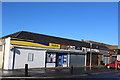
5
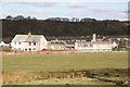
Logan Primary School
The council housing estate that the school serves dates from the mid 20th century. The homes were built in response to the need for new housing in the Cumnock area as new industrial estates opened after World War 2 and rationalisation took place in the local coal mining industry,resulting in fewer,but larger coal mines in the Cumnock and Auchinleck areas.
Image: © Bob Forrest
Taken: 20 Mar 2007
0.15 miles
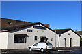
7

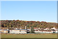
Logan
Council housing scheme located above the valley of the Lugar Water which has a history of flooding. The community is set in open countryside on the outskirts of Cumnock burgh. The minor road from the Glenmuir Water (Image) passes in front of the houses on its way to join the A70.
Image: © Bob Forrest
Taken: 20 Mar 2007
0.17 miles
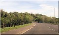
8
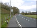
Barrhill Road
The A70 at Bridgend, Lugar.
Image: © Richard Webb
Taken: 5 May 2016
0.19 miles