IMAGES TAKEN NEAR TO
By Pass Road, BEITH, KA15 2HH
Introduction
This page details the photographs taken nearby to By Pass Road, KA15 2HH by members of the Geograph project.
The Geograph project started in 2005 with the aim of publishing, organising and preserving representative images for every square kilometre of Great Britain, Ireland and the Isle of Man.

There are currently over 7.5m images from over14,400 individuals and you can help contribute to the project by visiting https://www.geograph.org.uk
Image Map
Images are licensed for reuse under creativecommons.org/licenses/by-sa/2.0
Notes
- Clicking on the map will re-center to the selected point.
- The higher the marker number, the further away the image location is from the centre of the postcode.
Image Listing (40 Images Found)
Images are licensed for reuse under creativecommons.org/licenses/by-sa/2.0
Image
Details
Distance
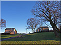
1
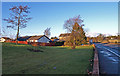
Green area beside A737, Beith
Houses on left are in Aitken Drive. The houses centre are Crummock Gardens. The building on the right is Crummock Farm.
Image: © wfmillar
Taken: 16 Dec 2010
0.04 miles
2
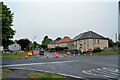
Head Street, Beith
Viewed across the A737 from Wardrop Street.
Head Street was temporarily closed to traffic on this day for resurfacing.
Image: © Richard Dorrell
Taken: 11 Aug 2021
0.08 miles
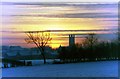
4
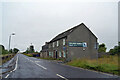
Beith Boys Brigade HQ
This building was originally built as a church in 1783. For more information read Old Beith by Donald L Reid published by Stenlake Publishing
www.stenlake.co.uk. ISBN 1840331267
Image: © Chris Court
Taken: 7 Aug 2005
0.09 miles
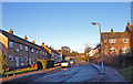
5
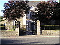
Wardrop Street, Beith
The road is the B777, here looking east from close to its junction with the A737.
The building on the right is currently in use for parade nights by the Garnock Valley detachment of the West Lowland Battalion, Army Cadets Force.
Image: © Richard Dorrell
Taken: 11 Aug 2021
0.10 miles
7
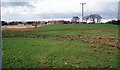
Power Line pole
View from B777 about 100m East of its junction with the A737 looking North. Pole for electricity supply and new telecoms mast (at the time) to the right of the photo. 25th March 2005 3.00p.m.
Image: © Gordon Dowie
Taken: 25 Mar 2005
0.13 miles
8
Crummock Gardens, Beith
Crummock House was demolished in 1960s and a housing estate built. Some trees and green areas saved.
Image: © wfmillar
Taken: 16 Dec 2010
0.15 miles
9
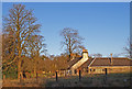
Crummock Farm, Beith
No longer a working farm.
Image: © wfmillar
Taken: 16 Dec 2010
0.16 miles
10
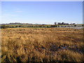
Hill of Beith
View across frozen boggy field to Hill of Beith.
Image: © Chris Court
Taken: 25 Dec 2005
0.17 miles