IMAGES TAKEN NEAR TO
Garrier Place, KILMARNOCK, KA1 2NG
Introduction
This page details the photographs taken nearby to Garrier Place, KA1 2NG by members of the Geograph project.
The Geograph project started in 2005 with the aim of publishing, organising and preserving representative images for every square kilometre of Great Britain, Ireland and the Isle of Man.

There are currently over 7.5m images from over14,400 individuals and you can help contribute to the project by visiting https://www.geograph.org.uk
Image Map (Loading...)


Getting Data...Please wait
Leaflet Map data © OpenStreetMap
Images are licensed for reuse under creativecommons.org/licenses/by-sa/2.0
Notes
- Clicking on the map will re-center to the selected point.
- The higher the marker number, the further away the image location is from the centre of the postcode.
Image Listing (45 Images Found)
Images are licensed for reuse under creativecommons.org/licenses/by-sa/2.0
Image
Details
Distance
1
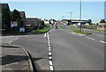
Munro Avenue, Kilmarnock
An early bypass. A Bellway sign on the right suggests that some former industrial land will be redeveloped for housing.
Image: © Richard Webb
Taken: 9 Sep 2009
0.06 miles
2
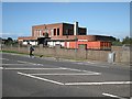
Derelict industrial building
Seen across Western Road, are the abandoned engineering offices for Post Office Telephones (now British Telecom (BT)). These offices were still in use during the late 1980's / early 1990's until centralisation meant they were no longer required.
There was a previous use for the BT building that being of company offices for Southook Potteries. This was part of Shanks (later known as Armitage Shanks). The take over of Shanks resulted in the closure of all premises in Kilmarnock and the building was taken over by Post Office Telephones.
Image: © Richard Webb
Taken: 9 Sep 2009
0.07 miles
3
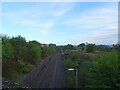
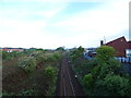
Passing loop on the former Kilmarnock to Crosshouse rail line
From the bridge on the B7064.
Image: © JThomas
Taken: 24 May 2021
0.09 miles
4
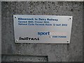
Plaque, National Cycle Network, route 73
Celebrating the conversion of a length of the Glasgow, Paisley, Kilmarnock and Ayr Railway into a cycle path. The railway was still shown on maps in 1976, and closed to passenger traffic along with the Kilbarchan Loop in 1966.
Image: © Richard Webb
Taken: 9 Sep 2009
0.09 miles
5

Milepost, National Cycle Network route 73
Situated at the start of a railway conversion: Western Road, Kilmarnock
Image: © Richard Webb
Taken: 9 Sep 2009
0.10 miles
6
Kilmarnock to Glasgow railway
From the bridge on the B7064.
Image: © JThomas
Taken: 24 May 2021
0.11 miles
7
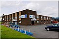
Ayrshire Agencies - Kilmarnock
Double glazing, Conservatory Roofs and furniture, patio doors...
Image: © Ian Rainey
Taken: 9 May 2019
0.11 miles
8
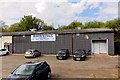
Brownings the Baker's Factory Building - Kilmarnock
Factory building across the road from the main factory building https://www.geograph.org.uk/photo/6132979
Image: © Ian Rainey
Taken: 25 Apr 2019
0.11 miles
9
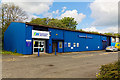
Electrical Network - Kilmarnock
Electrical wholesaler with a vast range of products available from stock
Image: © Ian Rainey
Taken: 25 Apr 2019
0.12 miles
10
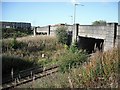
Railways, Kilmarnock
A bridge takes the B7064 over the trackbeds of two railways. The nearer line is still open and was the Glasgow and Kilmarnock Joint Railway running to Glasgow via
Stewarton. This was operated by the Caledonian Railway The further arch crosses the now closed Glasgow, Paisley, Kilmarnock and Ayr Railway a rival line operated by the Glasgow and South Western via Dalry. The Glasgow, Paisley, Kilmarnock and Ayr Railway track is still there in places, buried under vegetation. A 1976 map shows it as intact as far as Dalry. The line is now a cycle path, National Cycle Network route 73.
Image: © Richard Webb
Taken: 9 Sep 2009
0.13 miles