IMAGES TAKEN NEAR TO
Rosehaugh Crescent, AVOCH, IV9 8RS
Introduction
This page details the photographs taken nearby to Rosehaugh Crescent, IV9 8RS by members of the Geograph project.
The Geograph project started in 2005 with the aim of publishing, organising and preserving representative images for every square kilometre of Great Britain, Ireland and the Isle of Man.

There are currently over 7.5m images from over14,400 individuals and you can help contribute to the project by visiting https://www.geograph.org.uk
Image Map
Images are licensed for reuse under creativecommons.org/licenses/by-sa/2.0
Notes
- Clicking on the map will re-center to the selected point.
- The higher the marker number, the further away the image location is from the centre of the postcode.
Image Listing (33 Images Found)
Images are licensed for reuse under creativecommons.org/licenses/by-sa/2.0
Image
Details
Distance
1
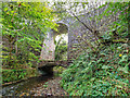
Disused Railway Bridge over the Avoch Burn
The Muir of Ord - Fortrose branch line crossed the Avoch Burn over this impressive and unusual bridge. It stands 40 feet high and is unusual in that it was built with a reinforcing brick arch. View looking South.
Image: © valenta
Taken: 15 Oct 2017
0.11 miles
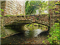
2
Disused Railway Bridge over the Avoch Burn
The Muir of Ord - Fortrose branch line crossed the Avoch Burn over this impressive and unusual bridge. It stands 40 feet high and is unusual in that it was built with a reinforcing brick arch above the base. View looking North
Image: © valenta
Taken: 15 Oct 2017
0.11 miles
3
Brick arch over the Avoch Burn
This disused railway bridge that carried the Fortrose branch line over the Avoch Burn is rather unusual in that it was built with this brick reinforcing arch.
Image: © valenta
Taken: 15 Oct 2017
0.11 miles
4
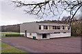
Avoch Sea Scout Training and Community Centre
Located at the end of Old Mill Road. The centre is owned by Avoch Amenities Association and operated by 1st Avoch Sea Scouts for the benefit of the community.
Image: © Richard Dorrell
Taken: 29 Dec 2013
0.13 miles
5
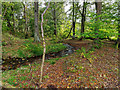
The Shaltie Burn
The Shaltie burn just before it runs into the Rosehaugh Burn.
Image: © valenta
Taken: 15 Oct 2017
0.13 miles
6
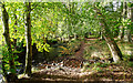
Confluence of the Shaltie Burn with the Rosehaugh Burn
The confluence of the Shaltie Burn with the Rosehaugh Burn, where it continues downstream and out to sea as the Avoch Burn.
Image: © valenta
Taken: 15 Oct 2017
0.14 miles
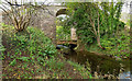
7
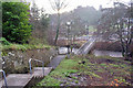
Path from Mackenzie Place
This stepped path connects Mackenzie Place to Old Mill Road. The footbridge crosses Avoch Burn. The Avoch Primary School is at the end of Old Mill Road. (See Image]).
Image: © Richard Dorrell
Taken: 29 Dec 2013
0.14 miles
8
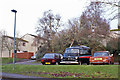
Classics Corner
These three vehicles are parked in a garage area off School Brae, Avoch. None is currently in road-going order, though they all look very tidy. On the right is a 1972/73 Rover 2000SC, and on the left an 1988/89 Austin Metro City. Centre is a very rare Bedford CA Dormobile, dating from the early 1960's. All three vehicles are in good enough condition to be of historical interest, so I hope they are not allowed to deteriorate any further where they stand.
Image: © Richard Dorrell
Taken: 29 Dec 2013
0.16 miles
9
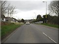
Avoch : Toll Road, A832
Heading along the A832 as it heads through Avoch.
Image: © Lewis Clarke
Taken: 23 Apr 2016
0.16 miles
10
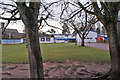
Avoch Primary School
The school currently has a roll of 256 children in 10 mainstream classes, plus a Nursery department.
Image: © Richard Dorrell
Taken: 29 Dec 2013
0.16 miles